Geolocate

Kettering topographic map

Click on the map to display elevation.

About this map

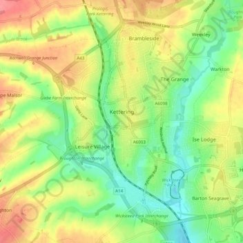
Name: Kettering topographic map, elevation, terrain.

Location: Kettering, North Northamptonshire, England, United Kingdom (52.37198 -0.75438 52.42193 -0.65740)

Average elevation: 289 ft

Minimum elevation: 174 ft

Maximum elevation: 427 ft

Other topographic maps

Click on a map to view its topography, its elevation and its terrain.

Mawsley

United Kingdom > England > North Northamptonshire

Average elevation: 423 ft

Laxton

United Kingdom > England > North Northamptonshire

Average elevation: 282 ft

Gear up for your next adventure:

🌐World Map Poster - Decorative world maps with topographic info
🛶Inflatable Kayak - Portable kayak for rivers, lakes, and expeditions
🚗GPS Dash Cams - Record your scenic drives through mountain passes and canyons
🪶Camping Sleeping Pad - Comfortable sleeping pad for backpacking
🛠️Outdoor Gear Repair Kit - Essential tools to fix gear on the trail

As an Amazon Associate, this site earns from qualifying purchases at no extra cost to you.