
Make a donation
Gear up for your next adventure:
As an Amazon Associate, this site earns from qualifying purchases at no extra cost to you.
Little Stanion topographic map
Click on the map to display elevation.
Make a donation
Gear up for your next adventure:
As an Amazon Associate, this site earns from qualifying purchases at no extra cost to you.
About this map
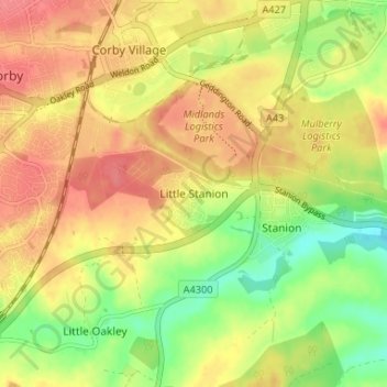
Name: Little Stanion topographic map, elevation, terrain.
Average elevation: 318 ft
Minimum elevation: 200 ft
Maximum elevation: 404 ft
Make a donation
Gear up for your next adventure:
As an Amazon Associate, this site earns from qualifying purchases at no extra cost to you.
Other topographic maps
Click on a map to view its topography, its elevation and its terrain.
Irchester Country Park
United Kingdom > England > North Northamptonshire > Little Irchester
Average elevation: 197 ft
Make a donation
Gear up for your next adventure:
As an Amazon Associate, this site earns from qualifying purchases at no extra cost to you.
River Nene Navigation
United Kingdom > England > North Northamptonshire > Irchester
Average elevation: 180 ft
Make a donation
Gear up for your next adventure:
As an Amazon Associate, this site earns from qualifying purchases at no extra cost to you.
Make a donation
Gear up for your next adventure:
As an Amazon Associate, this site earns from qualifying purchases at no extra cost to you.
Make a donation
Gear up for your next adventure:
As an Amazon Associate, this site earns from qualifying purchases at no extra cost to you.
Make a donation
Gear up for your next adventure:
As an Amazon Associate, this site earns from qualifying purchases at no extra cost to you.
Earls Barton
United Kingdom > England > North Northamptonshire > Earls Barton
Average elevation: 230 ft
Make a donation
Gear up for your next adventure:
As an Amazon Associate, this site earns from qualifying purchases at no extra cost to you.
Irchester
United Kingdom > England > North Northamptonshire
The 12th-century English historian Henry of Huntingdon mentions a Roman "town on the river (Nene), in Huntingdonshire, which is entirely destroyed" as one of his interpretations of the 28 cities of Britain. The town is mentioned also by William Lambarde in Dictionarium Angliae Topographicum & Historicum.
Average elevation: 203 ft
Make a donation
Gear up for your next adventure:
As an Amazon Associate, this site earns from qualifying purchases at no extra cost to you.
Make a donation
Gear up for your next adventure:
As an Amazon Associate, this site earns from qualifying purchases at no extra cost to you.
King's Cliffe
United Kingdom > England > North Northamptonshire > King's Cliffe
Average elevation: 226 ft
Make a donation
Gear up for your next adventure:
As an Amazon Associate, this site earns from qualifying purchases at no extra cost to you.
Make a donation
Gear up for your next adventure:
As an Amazon Associate, this site earns from qualifying purchases at no extra cost to you.
Make a donation
Gear up for your next adventure:
As an Amazon Associate, this site earns from qualifying purchases at no extra cost to you.
Easton on the Hill
United Kingdom > England > North Northamptonshire > Easton on the Hill
Average elevation: 233 ft
Barton Seagrave
United Kingdom > England > North Northamptonshire
Other natives of the village include topographer John Bridges and his brother, Charles, a painter.
Average elevation: 256 ft
Make a donation
Gear up for your next adventure:
As an Amazon Associate, this site earns from qualifying purchases at no extra cost to you.
Make a donation
Gear up for your next adventure:
As an Amazon Associate, this site earns from qualifying purchases at no extra cost to you.
Make a donation
Gear up for your next adventure:
As an Amazon Associate, this site earns from qualifying purchases at no extra cost to you.
Finedon
United Kingdom > England > North Northamptonshire
The town of Finedon rises to approximately 90 metres Above Ordinance Datum from the River Ise, with the historical centre of the settlement occupying a shallow south-west facing valley. The contemporary point of maximum elevation in the parish is the summit of the disused Sidegate Lane Landfill Site, located…
Average elevation: 246 ft
Make a donation
Gear up for your next adventure:
As an Amazon Associate, this site earns from qualifying purchases at no extra cost to you.
Irchester
United Kingdom > England > North Northamptonshire
The 12th-century English historian Henry of Huntingdon mentions a Roman "town on the river (Nene), in Huntingdonshire, which is entirely destroyed" as one of his interpretations of the 28 cities of Britain. The town is mentioned also by William Lambarde in Dictionarium Angliae Topographicum & Historicum.
Average elevation: 203 ft
Make a donation
Gear up for your next adventure:
As an Amazon Associate, this site earns from qualifying purchases at no extra cost to you.
Make a donation
Gear up for your next adventure:
As an Amazon Associate, this site earns from qualifying purchases at no extra cost to you.
Make a donation
Gear up for your next adventure:
As an Amazon Associate, this site earns from qualifying purchases at no extra cost to you.