Geolocate

Bem topographic map

Click on the map to display elevation.

About this map

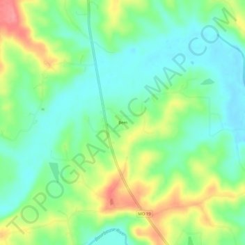
Name: Bem topographic map, elevation, terrain.

Location: Bem, Gasconade County, Missouri, United States (38.24588 -91.48988 38.28588 -91.44988)

Average elevation: 814 ft

Minimum elevation: 715 ft

Maximum elevation: 988 ft

Gasconade County trails, hiking, mountain biking, running and outdoor activities

Other topographic maps

Click on a map to view its topography, its elevation and its terrain.

Hermann

United States > Missouri > Gasconade County

Average elevation: 623 ft

Bland

United States > Missouri > Gasconade County

Average elevation: 928 ft

Owensville

United States > Missouri > Gasconade County

Average elevation: 915 ft

Gear up for your next adventure:

📱Heavy-Duty Phone Cases - Drop-proof and waterproof protection for outdoor navigation
🪓Survival Multi‑Tool - Versatile tool for camp and trail tasks
🪶Trail Camera - Capture wildlife on your hikes
🪶Wildlife Field Guides - Learn animal tracking and species ID
🩳Quick‑Dry Hiking Shorts - Comfortable and quick‑dry shorts for summer hiking

As an Amazon Associate, this site earns from qualifying purchases at no extra cost to you.