Geolocate

Hermann topographic map

Click on the map to display elevation.

About this map

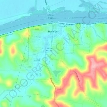
Name: Hermann topographic map, elevation, terrain.

Location: Hermann, Gasconade County, Missouri, 65941, United States (38.68068 -91.45558 38.70990 -91.40002)

Average elevation: 623 ft

Minimum elevation: 492 ft

Maximum elevation: 965 ft

Gasconade County trails, hiking, mountain biking, running and outdoor activities

Other topographic maps

Click on a map to view its topography, its elevation and its terrain.

Bay

United States > Missouri > Gasconade County

Average elevation: 633 ft

Hermann

United States > Missouri > Gasconade County > Hermann > Hermann

Average elevation: 597 ft

Gear up for your next adventure:

🪶Wildlife Field Guides - Learn animal tracking and species ID
🎒Waterproof Dry Bags - Keep your electronics and maps dry inside your pack
🪶Fire Starter Kit - Reliable fire starter for survival and camping
👓Polarized Sunglasses - Outdoor sunglasses for glare reduction
👟Men's Trail Runners - Lightweight footwear for fast-paced exploration and light hiking

As an Amazon Associate, this site earns from qualifying purchases at no extra cost to you.