Geolocate

Sittingbourne topographic map

Click on the map to display elevation.

About this map

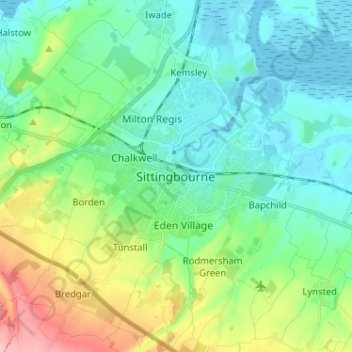
Name: Sittingbourne topographic map, elevation, terrain.

Location: Sittingbourne, Borough of Swale, Kent, England, ME10 4AL, United Kingdom (51.29974 0.69423 51.37974 0.77423)

Average elevation: 121 ft

Minimum elevation: -7 ft

Maximum elevation: 456 ft

Other topographic maps

Click on a map to view its topography, its elevation and its terrain.

The Swale

United Kingdom > England > Kent > Borough of Swale

Average elevation: 39 ft

Milstead

United Kingdom > England > Kent > Borough of Swale > Milstead

Average elevation: 348 ft

Borden

United Kingdom > England > Kent > Borough of Swale > Borden

Average elevation: 210 ft

Lower Halstow

United Kingdom > England > Kent > Borough of Swale

Average elevation: 39 ft

Newington

United Kingdom > England > Kent > Borough of Swale

Average elevation: 148 ft

Bobbing

United Kingdom > England > Kent > Borough of Swale

Average elevation: 105 ft

Newnham

United Kingdom > England > Kent > Borough of Swale > Newnham

Average elevation: 292 ft

Newnham

United Kingdom > England > Kent > Borough of Swale > Newnham

Average elevation: 292 ft

Faversham

United Kingdom > England > Kent > Borough of Swale

Average elevation: 56 ft

Hernhill

United Kingdom > England > Kent > Borough of Swale > Dargate

Average elevation: 95 ft

Sheldwich

United Kingdom > England > Kent > Borough of Swale

Average elevation: 230 ft

Selling

United Kingdom > England > Kent > Borough of Swale

Average elevation: 210 ft

Eastchurch

United Kingdom > England > Kent > Borough of Swale

Average elevation: 52 ft

Stalisfield

United Kingdom > England > Kent > Borough of Swale

Average elevation: 449 ft

Luddenham

United Kingdom > England > Kent > Borough of Swale > Oare

Average elevation: 23 ft

Luddenham

United Kingdom > England > Kent > Borough of Swale

Average elevation: 23 ft

Oare Creek

United Kingdom > England > Kent > Borough of Swale > Faversham > Oare

Average elevation: 20 ft

Faversham

United Kingdom > England > Kent > Borough of Swale > Ospringe

Average elevation: 56 ft

Iwade

United Kingdom > England > Kent > Borough of Swale

Average elevation: 20 ft

Upchurch

United Kingdom > England > Kent > Borough of Swale

Average elevation: 33 ft

Bapchild

United Kingdom > England > Kent > Borough of Swale > Bapchild

Average elevation: 69 ft

Sheerness

United Kingdom > England > Kent > Borough of Swale

Average elevation: 10 ft

Tonge

United Kingdom > England > Kent > Borough of Swale > Bapchild

Average elevation: 75 ft

Hartlip

United Kingdom > England > Kent > Borough of Swale > Hartlip

Average elevation: 230 ft

Oare

United Kingdom > England > Kent > Borough of Swale > Oare

Average elevation: 13 ft

Queenborough

United Kingdom > England > Kent > Borough of Swale

Average elevation: 7 ft

Lewson Street

United Kingdom > England > Kent > Borough of Swale > Norton

Average elevation: 118 ft

Bredgar

United Kingdom > England > Kent > Borough of Swale

Average elevation: 328 ft

Teynham

United Kingdom > England > Kent > Borough of Swale

Average elevation: 20 ft

Doddington

United Kingdom > England > Kent > Borough of Swale > Doddington

Average elevation: 338 ft

Sheerness

United Kingdom > England > Kent > Borough of Swale

Average elevation: 10 ft

Gear up for your next adventure:

🧭GPS Watch Accessories - Bands and chargers for GPS watches
📷Action Camera - Capture your outdoor adventures in HD
🥘Titanium Cookware - Durable, featherlight pots and pans for backpacking
🛡️Insect Repellent - Protection against bugs during outdoor activities
🧯Emergency Survival Kit - All‑in‑one survival essentials for the backcountry

As an Amazon Associate, this site earns from qualifying purchases at no extra cost to you.