
Make a donation
Gear up for your next adventure:
As an Amazon Associate, this site earns from qualifying purchases at no extra cost to you.
Upchurch topographic map
Click on the map to display elevation.
Make a donation
Gear up for your next adventure:
As an Amazon Associate, this site earns from qualifying purchases at no extra cost to you.
About this map
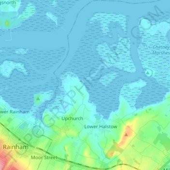
Name: Upchurch topographic map, elevation, terrain.
Location: Upchurch, Borough of Swale, Kent, England, United Kingdom (51.35296 0.62326 51.42927 0.69736)
Average elevation: 33 ft
Minimum elevation: -10 ft
Maximum elevation: 285 ft
Make a donation
Gear up for your next adventure:
As an Amazon Associate, this site earns from qualifying purchases at no extra cost to you.
Other topographic maps
Click on a map to view its topography, its elevation and its terrain.
Make a donation
Gear up for your next adventure:
As an Amazon Associate, this site earns from qualifying purchases at no extra cost to you.
Make a donation
Gear up for your next adventure:
As an Amazon Associate, this site earns from qualifying purchases at no extra cost to you.
Faversham Creek
United Kingdom > England > Kent > Borough of Swale > Faversham > Oare
Average elevation: 36 ft
Make a donation
Gear up for your next adventure:
As an Amazon Associate, this site earns from qualifying purchases at no extra cost to you.
Hickmans Green
United Kingdom > England > Kent > Borough of Swale > Boughton Street
Average elevation: 207 ft
Oare Creek
United Kingdom > England > Kent > Borough of Swale > Faversham > Oare
Average elevation: 20 ft
Make a donation
Gear up for your next adventure:
As an Amazon Associate, this site earns from qualifying purchases at no extra cost to you.
Make a donation
Gear up for your next adventure:
As an Amazon Associate, this site earns from qualifying purchases at no extra cost to you.
Faversham Creek
United Kingdom > England > Kent > Borough of Swale > Faversham > Oare
Average elevation: 26 ft
Make a donation
Gear up for your next adventure:
As an Amazon Associate, this site earns from qualifying purchases at no extra cost to you.
Rodmersham Green
United Kingdom > England > Kent > Borough of Swale > Rodmersham Green
Average elevation: 157 ft
Whitehill
United Kingdom > England > Kent > Borough of Swale > Painter's Forstal
Average elevation: 148 ft
Make a donation
Gear up for your next adventure:
As an Amazon Associate, this site earns from qualifying purchases at no extra cost to you.
Make a donation
Gear up for your next adventure:
As an Amazon Associate, this site earns from qualifying purchases at no extra cost to you.
Make a donation
Gear up for your next adventure:
As an Amazon Associate, this site earns from qualifying purchases at no extra cost to you.