
Thank you for supporting this site ❤️
Make a donation
Make a donation
Gear up for your next adventure:
As an Amazon Associate, this site earns from qualifying purchases at no extra cost to you.
Campodonico topographic map
Click on the map to display elevation.
Thank you for supporting this site ❤️
Make a donation
Make a donation
Gear up for your next adventure:
As an Amazon Associate, this site earns from qualifying purchases at no extra cost to you.
About this map
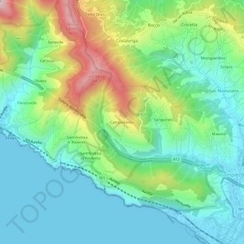
Name: Campodonico topographic map, elevation, terrain.
Location: Campodonico, Chiavari, Genoa, Liguria, 16043, Italy (44.31716 9.27484 44.35716 9.31484)
Average elevation: 548 ft
Minimum elevation: 0 ft
Maximum elevation: 1,900 ft
Thank you for supporting this site ❤️
Make a donation
Make a donation
Gear up for your next adventure:
As an Amazon Associate, this site earns from qualifying purchases at no extra cost to you.