
Utica topographic map
Click on the map to display elevation.
About this map
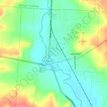
Name: Utica topographic map, elevation, terrain.
Average elevation: 1,020 ft
Minimum elevation: 932 ft
Maximum elevation: 1,171 ft
Licking County trails, hiking, mountain biking, running and outdoor activities
Other topographic maps
Click on a map to view its topography, its elevation and its terrain.
Etna
United States > Ohio > Licking County
Etna (formerly Carthage) is an unincorporated community and census-designated place (CDP) in Licking County, Ohio, United States. As of the 2020 census it had a population of 1,209. It lies at an elevation of 1,069 feet (326 m) at the intersection of U.S. Route 40 and State Route 310. It was listed as a…
Average elevation: 1,053 ft