
Make a donation
Gear up for your next adventure:
As an Amazon Associate, this site earns from qualifying purchases at no extra cost to you.
Leeward Islands topographic map
Click on the map to display elevation.
Make a donation
Gear up for your next adventure:
As an Amazon Associate, this site earns from qualifying purchases at no extra cost to you.
About this map
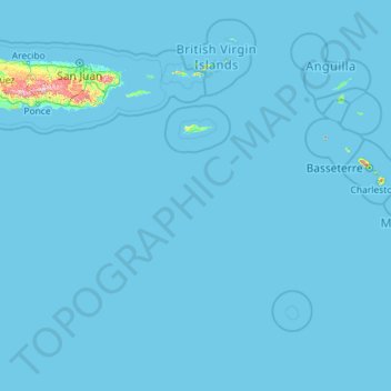
Name: Leeward Islands topographic map, elevation, terrain.
Location: Leeward Islands, United States Virgin Islands, United States (15.20763 -65.57778 18.74958 -61.00130)
Average elevation: 30 ft
Minimum elevation: -3 ft
Maximum elevation: 3,799 ft
United States Virgin Islands trails, hiking, mountain biking, running and outdoor activities
Make a donation
Gear up for your next adventure:
As an Amazon Associate, this site earns from qualifying purchases at no extra cost to you.
Other topographic maps
Click on a map to view its topography, its elevation and its terrain.
Francis Bay
United States > United States Virgin Islands > Saint Thomas - Saint John District
Average elevation: 85 ft
Charlotte Amalie West
United States > United States Virgin Islands > Saint Thomas - Saint John District
Average elevation: 171 ft
Botany Bay
United States > United States Virgin Islands > Saint Thomas - Saint John District
Average elevation: 95 ft
Make a donation
Gear up for your next adventure:
As an Amazon Associate, this site earns from qualifying purchases at no extra cost to you.
Dry Rock
United States > United States Virgin Islands > Saint Thomas - Saint John District
Average elevation: 10 ft
Prospect Hill
United States > United States Virgin Islands > Saint Croix District
Average elevation: 361 ft
Charlotte Amalie
United States > United States Virgin Islands > Saint Thomas - Saint John District > Charlotte Amalie
Average elevation: 203 ft
Morningstar
United States > United States Virgin Islands > Saint Croix District > Morningstar
Average elevation: 223 ft
Make a donation
Gear up for your next adventure:
As an Amazon Associate, this site earns from qualifying purchases at no extra cost to you.
Cartlon South
United States > United States Virgin Islands > Saint Croix District > Cartlon South
Average elevation: 75 ft
Longford (Anna's Hope Village)
United States > United States Virgin Islands > Saint Croix District
Average elevation: 161 ft