
Make a donation
Gear up for your next adventure:
As an Amazon Associate, this site earns from qualifying purchases at no extra cost to you.
Tambillo topographic map
Click on the map to display elevation.
Make a donation
Gear up for your next adventure:
As an Amazon Associate, this site earns from qualifying purchases at no extra cost to you.
About this map
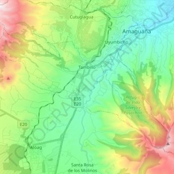
Name: Tambillo topographic map, elevation, terrain.
Location: Tambillo, Machachi, Pichincha, 171106, Ecuador (-0.46943 -78.61815 -0.37282 -78.48028)
Average elevation: 10,026 ft
Minimum elevation: 8,228 ft
Maximum elevation: 14,039 ft
Make a donation
Gear up for your next adventure:
As an Amazon Associate, this site earns from qualifying purchases at no extra cost to you.
Other topographic maps
Click on a map to view its topography, its elevation and its terrain.
Volcán Cotopaxi
El Cotopaxi (pronunciado [ko.toˈpak.si]) es un estratovolcán activo, situado en el centro-norte de Ecuador, en la Provincia de Cotopaxi. Perteneciente a la cordillera de los Andes, específicamente a los Andes septentrionales, cuenta con una altitud de 5897 m s. n. m.; por lo que es la segunda montaña más…
Average elevation: 16,473 ft
Manuel Cornejo Astorga Tandapi
Ecuador > Machachi > Manuel Cornejo Astorga (Tandapi)
Average elevation: 5,801 ft
Make a donation
Gear up for your next adventure:
As an Amazon Associate, this site earns from qualifying purchases at no extra cost to you.
Make a donation
Gear up for your next adventure:
As an Amazon Associate, this site earns from qualifying purchases at no extra cost to you.
Manuel Cornejo Astorga Tandapi
Ecuador > Machachi > Manuel Cornejo Astorga (Tandapi)
Average elevation: 5,801 ft