Geolocate

Grovetown topographic map

Click on the map to display elevation.

About this map

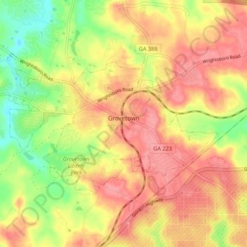
Name: Grovetown topographic map, elevation, terrain.

Location: Grovetown, Columbia County, Georgia, United States (33.43112 -82.24475 33.46690 -82.16920)

Average elevation: 440 ft

Minimum elevation: 266 ft

Maximum elevation: 558 ft

Columbia County trails, hiking, mountain biking, running and outdoor activities

Other topographic maps

Click on a map to view its topography, its elevation and its terrain.

Kiokee

United States > Georgia > Columbia County

Average elevation: 272 ft

Idylwilde

United States > Georgia > Columbia County

Average elevation: 390 ft

Leah

United States > Georgia > Columbia County

Average elevation: 407 ft

Campania

United States > Georgia > Columbia County

Average elevation: 482 ft

Gear up for your next adventure:

🧭Hiking Compass - Precision compass for reliable navigation in the wilderness
🧺Microfiber Travel Towels - Compact and fast-drying towels for trail use
🥾Women's Hiking Boots - Top-rated trail boots with ankle support and superior grip
😴Insulated Sleeping Pads - Compact and warm pads for high-elevation camping
🔦LED Headlamp - Bright and durable LED headlamp for night navigation

As an Amazon Associate, this site earns from qualifying purchases at no extra cost to you.