
Appling topographic map
Click on the map to display elevation.
About this map
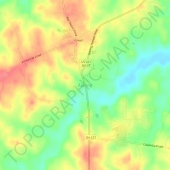
Name: Appling topographic map, elevation, terrain.
Location: Appling, Columbia County, Georgia, United States (33.52597 -82.33596 33.56597 -82.29596)
Average elevation: 335 ft
Minimum elevation: 217 ft
Maximum elevation: 446 ft
Columbia County trails, hiking, mountain biking, running and outdoor activities
Other topographic maps
Click on a map to view its topography, its elevation and its terrain.
Martinez
United States > Georgia > Columbia County > Augusta
Martinez has an elevation of 361 feet (110 m) above sea level, about 200 feet (61 m) higher than downtown Augusta. The areas of the CDP closest to the Richmond County line tend to be relatively flat, while land further west is hillier. Trees in Martinez are seen mainly in the subdivisions, as the main roads…
Average elevation: 351 ft