
Bubenbach topographic map
Click on the map to display elevation.
Bubenbach
It lies at an altitude between 800 and 1130m above sea level in the Breg valley.
About this map
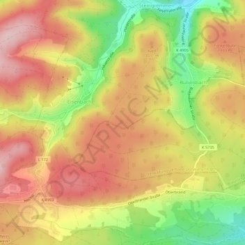
Name: Bubenbach topographic map, elevation, terrain.
Average elevation: 3,241 ft
Minimum elevation: 2,831 ft
Maximum elevation: 3,455 ft
Other topographic maps
Click on a map to view its topography, its elevation and its terrain.
Kaiserstuhl
Germany > Baden-Württemberg > Landkreis Breisgau-Hochschwarzwald
Average elevation: 810 ft
Wolfenweiler
Germany > Baden-Württemberg > Landkreis Breisgau-Hochschwarzwald
Average elevation: 856 ft
Rheintal
Germany > Baden-Württemberg > Landkreis Breisgau-Hochschwarzwald > Müllheim im Markgräflerland
Average elevation: 1,391 ft
Dietenbach
Germany > Baden-Württemberg > Landkreis Breisgau-Hochschwarzwald > Kirchzarten (Kernort) > Kirchzarten
Average elevation: 1,581 ft