Geolocate

Lowman topographic map

Click on the map to display elevation.

About this map

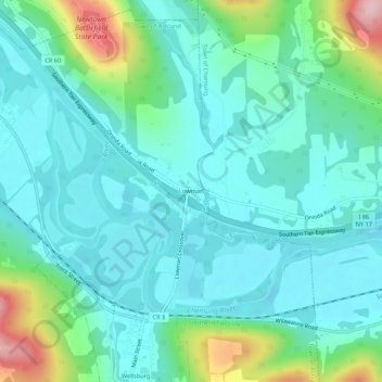
Name: Lowman topographic map, elevation, terrain.

Location: Lowman, Town of Ashland, Chemung County, New York, 14894, United States (42.00980 -76.74051 42.04980 -76.70051)

Average elevation: 951 ft

Minimum elevation: 781 ft

Maximum elevation: 1,572 ft

Chemung County trails, hiking, mountain biking, running and outdoor activities

Other topographic maps

Click on a map to view its topography, its elevation and its terrain.

Big Flats

United States > New York > Chemung County

Average elevation: 1,243 ft

Town of Chemung

United States > New York > Chemung County

Average elevation: 1,220 ft

Pine Valley

United States > New York > Chemung County

Average elevation: 1,053 ft

Van Etten

United States > New York > Chemung County > Van Etten

Average elevation: 1,181 ft

Town of Baldwin

United States > New York > Chemung County

Average elevation: 1,293 ft

Town of Ashland

United States > New York > Chemung County

Average elevation: 1,178 ft

Town of Horseheads

United States > New York > Chemung County

Average elevation: 1,142 ft

Town of Southport

United States > New York > Chemung County

Average elevation: 1,270 ft

Gear up for your next adventure:

🪑Portable Camp Table - Compact table for campsite meals
Backpacking Tent - Lightweight and durable tent for multi‑day hikes
🗻Climbing Gear Basics - Essential gear for beginner climbers
🌄Hiking Binoculars - Compact binoculars for scenic views and trail spotting
🪶Thermal Camp Blanket - Extra warmth for cold nights

As an Amazon Associate, this site earns from qualifying purchases at no extra cost to you.