
Village of Millport topographic map
Interactive map
Click on the map to display elevation.
About this map
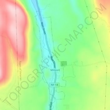
Name: Village of Millport topographic map, elevation, terrain.
Average elevation: 971 ft
Minimum elevation: 640 ft
Maximum elevation: 1,401 ft
Other topographic maps
Click on a map to view its topography, its elevation and its terrain.
Town of Baldwin
United States > New York > Chemung County
Town of Baldwin, Chemung County, New York, 14861, United States
Average elevation: 1,293 ft
Village of Elmira Heights
United States > New York > Chemung County > Town of Horseheads
Village of Elmira Heights, Town of Horseheads, Chemung County, New York, United States
Average elevation: 912 ft
Town of Chemung
United States > New York > Chemung County
Town of Chemung, Chemung County, New York, 14825, United States
Average elevation: 1,220 ft
Pine Valley
United States > New York > Chemung County
Pine Valley, Town of Veteran, Chemung County, New York, 14872, United States
Average elevation: 1,053 ft
Big Flats
United States > New York > Chemung County
Big Flats, Town of Big Flats, Chemung County, New York, 14814, United States
Average elevation: 1,243 ft
Village of Horseheads
United States > New York > Chemung County > Town of Horseheads
Village of Horseheads, Town of Horseheads, Chemung County, New York, 14845, United States
Average elevation: 978 ft
Van Etten
United States > New York > Chemung County
Van Etten, Town of Van Etten, Chemung County, New York, United States
Average elevation: 1,181 ft
Town of Southport
United States > New York > Chemung County
Town of Southport, Chemung County, New York, 14871, United States
Average elevation: 1,270 ft
Lowman
United States > New York > Chemung County
Lowman, Town of Ashland, Chemung County, New York, 14894, United States
Average elevation: 951 ft
Breesport
United States > New York > Chemung County > Town of Horseheads
Breesport, Town of Horseheads, Chemung County, New York, 14816, United States
Average elevation: 1,227 ft
Town of Erin
United States > New York > Chemung County
Town of Erin, Chemung County, New York, 14838, United States
Average elevation: 1,470 ft
Pine City
United States > New York > Chemung County > Town of Southport
Pine City, Town of Southport, Chemung County, New York, 14871, United States
Average elevation: 1,263 ft
Village of Wellsburg
United States > New York > Chemung County
Village of Wellsburg, Town of Ashland, Chemung County, New York, United States
Average elevation: 1,040 ft
Chambers
United States > New York > Chemung County > Chambers
Chambers, Town of Catlin, Chemung County, New York, 14812, United States
Average elevation: 1,522 ft
Horseheads
United States > New York > Chemung County > Horseheads
Horseheads, Town of Horseheads, Chemung County, New York, 14845-2159, United States
Average elevation: 1,089 ft
Elmira
United States > New York > Chemung County
Elmira, City of Elmira, Chemung County, New York, 14901, United States
Average elevation: 1,362 ft
City of Elmira
United States > New York > Chemung County
City of Elmira, Chemung County, New York, United States
Average elevation: 971 ft
West Elmira
United States > New York > Chemung County
West Elmira, Town of Elmira, Chemung County, New York, 14905, United States
Average elevation: 1,050 ft