Geolocate

Estillfork topographic map

Click on the map to display elevation.

About this map

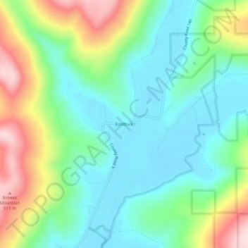
Name: Estillfork topographic map, elevation, terrain.

Location: Estillfork, Jackson County, Alabama, 35745, United States (34.89009 -86.19054 34.93009 -86.15054)

Average elevation: 978 ft

Minimum elevation: 636 ft

Maximum elevation: 1,722 ft

Jackson County trails, hiking, mountain biking, running and outdoor activities

Other topographic maps

Click on a map to view its topography, its elevation and its terrain.

Skyline

United States > Alabama > Jackson County

Average elevation: 1,276 ft

Langston

United States > Alabama > Jackson County

Average elevation: 797 ft

Paint Rock

United States > Alabama > Jackson County

Average elevation: 810 ft

Pleasant Groves

United States > Alabama > Jackson County

Average elevation: 1,086 ft

Hytop

United States > Alabama > Jackson County

Average elevation: 1,355 ft

Dutton

United States > Alabama > Jackson County

Average elevation: 1,345 ft

Scottsboro

United States > Alabama > Jackson County

Average elevation: 771 ft

Stevenson

United States > Alabama > Jackson County

Average elevation: 810 ft

Paint Rock

United States > Alabama > Jackson County

Average elevation: 817 ft

Pisgah

United States > Alabama > Jackson County > Pisgah

Average elevation: 1,375 ft

Gear up for your next adventure:

📶Vehicle Signal Boosters - Improve reception in rural areas while driving to trailheads
👖Convertible Hiking Pants - Versatile zip-off pants for changing altitudes and temperatures
🪶Fire Starter Kit - Reliable fire starter for survival and camping
🔦LED Headlamp - Bright and durable LED headlamp for night navigation
🩳Quick‑Dry Hiking Shorts - Comfortable and quick‑dry shorts for summer hiking

As an Amazon Associate, this site earns from qualifying purchases at no extra cost to you.