Geolocate

Hepburn topographic map

Click on the map to display elevation.

About this map

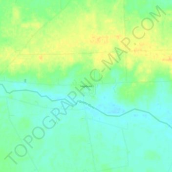
Name: Hepburn topographic map, elevation, terrain.

Location: Hepburn, Dudley Township, Hardin County, Ohio, United States (40.60098 -83.48928 40.64098 -83.44928)

Average elevation: 965 ft

Minimum elevation: 925 ft

Maximum elevation: 1,010 ft

Hardin County trails, hiking, mountain biking, running and outdoor activities

Other topographic maps

Click on a map to view its topography, its elevation and its terrain.

Ada

United States > Ohio > Hardin County

Average elevation: 961 ft

Kenton

United States > Ohio > Hardin County

Average elevation: 981 ft

Alger

United States > Ohio > Hardin County

Average elevation: 997 ft

Dunkirk

United States > Ohio > Hardin County

Average elevation: 942 ft

Forest

United States > Ohio > Hardin County

Average elevation: 928 ft

McGuffey

United States > Ohio > Hardin County

Average elevation: 971 ft

Mount Victory

United States > Ohio > Hardin County

Average elevation: 1,040 ft

Patterson

United States > Ohio > Hardin County

Average elevation: 922 ft

Ridgeway

United States > Ohio > Hardin County

Average elevation: 1,060 ft

Buck Township

United States > Ohio > Hardin County

Average elevation: 994 ft

Gear up for your next adventure:

📡GPS Antenna Upgrade - Enhance GPS reception in remote terrain
🧦Hiking Socks - Comfortable socks to prevent blisters on long hikes
🪶LED Camping Lantern - Bright lantern for camp lighting
😴Insulated Sleeping Pads - Compact and warm pads for high-elevation camping
📻Weather Alert Radios - Stay informed of storm risks while off-the-grid

As an Amazon Associate, this site earns from qualifying purchases at no extra cost to you.