
Bat Cave topographic map
Click on the map to display elevation.
About this map
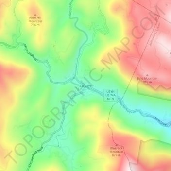
Name: Bat Cave topographic map, elevation, terrain.
Average elevation: 2,126 ft
Minimum elevation: 1,194 ft
Maximum elevation: 3,199 ft
Henderson County trails, hiking, mountain biking, running and outdoor activities
Other topographic maps
Click on a map to view its topography, its elevation and its terrain.
Etowah
United States > North Carolina > Henderson County
Etowah has an altitude of 2,101 feet (640 m).
Average elevation: 2,139 ft
Hendersonville Reservoir
United States > North Carolina > Henderson County
Average elevation: 2,805 ft
Mills River
United States > North Carolina > Henderson County > Mills River
Average elevation: 2,251 ft
Mills River
United States > North Carolina > Henderson County > Mills River > Oak Hill Court
Average elevation: 2,113 ft