Geolocate

Proctor topographic map

Click on the map to display elevation.

About this map

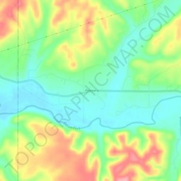
Name: Proctor topographic map, elevation, terrain.

Location: Proctor, Adair County, Oklahoma, United States (35.94620 -94.79745 35.98620 -94.75745)

Average elevation: 892 ft

Minimum elevation: 748 ft

Maximum elevation: 1,106 ft

Other topographic maps

Click on a map to view its topography, its elevation and its terrain.

Watts

United States > Oklahoma > Adair County

Average elevation: 1,030 ft

Stilwell

United States > Oklahoma > Adair County

Average elevation: 1,155 ft

Cherry Tree

United States > Oklahoma > Adair County

Average elevation: 1,096 ft

Gear up for your next adventure:

🪶Wildlife Field Guides - Learn animal tracking and species ID
🔥Plasma Lighters - Windproof lighters that work in any weather condition
📡Handheld GPS Device - Reliable handheld GPS for outdoor navigation
🏕️Tent Footprint - Protect your tent base from wear
🛏️Cold Weather Sleeping Bag - Warm sleeping bag for cold conditions

As an Amazon Associate, this site earns from qualifying purchases at no extra cost to you.