Geolocate

Cherry Tree topographic map

Click on the map to display elevation.

About this map

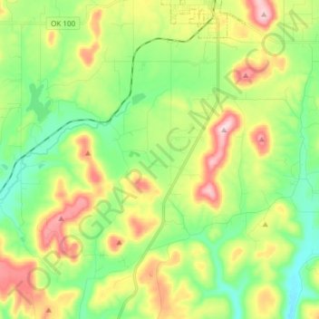
Name: Cherry Tree topographic map, elevation, terrain.

Location: Cherry Tree, Adair County, Oklahoma, United States (35.69803 -94.73215 35.79297 -94.58147)

Average elevation: 1,096 ft

Minimum elevation: 774 ft

Maximum elevation: 1,634 ft

Other topographic maps

Click on a map to view its topography, its elevation and its terrain.

Proctor

United States > Oklahoma > Adair County

Average elevation: 892 ft

Baron

United States > Oklahoma > Adair County

Average elevation: 971 ft

Christie

United States > Oklahoma > Adair County

Average elevation: 928 ft

Gear up for your next adventure:

🛌Ultralight Sleeping Bags - Compact down bags for cold nights in the wilderness
🎒Outdoor Daypacks - Lightweight backpacks designed for carrying maps and essential gear
🎒Gear Packing Cubes - Organize your backpack efficiently
🧼Biodegradable Camping Soap - Eco‑friendly soap for outdoor hygiene
🧭Map Reading Tools - Tools and kits for map navigation

As an Amazon Associate, this site earns from qualifying purchases at no extra cost to you.