
Ihringen topographic map
Click on the map to display elevation.
About this map
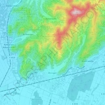
Name: Ihringen topographic map, elevation, terrain.
Average elevation: 837 ft
Minimum elevation: 597 ft
Maximum elevation: 1,778 ft
Other topographic maps
Click on a map to view its topography, its elevation and its terrain.
Kaiserstuhl
Germany > Baden-Württemberg > Landkreis Breisgau-Hochschwarzwald
Average elevation: 810 ft
Wolfenweiler
Germany > Baden-Württemberg > Landkreis Breisgau-Hochschwarzwald
Average elevation: 856 ft
Rheintal
Germany > Baden-Württemberg > Landkreis Breisgau-Hochschwarzwald > Müllheim im Markgräflerland
Average elevation: 1,391 ft
Dietenbach
Germany > Baden-Württemberg > Landkreis Breisgau-Hochschwarzwald > Kirchzarten (Kernort) > Kirchzarten
Average elevation: 1,581 ft