
Spring Valley topographic map
Click on the map to display elevation.
About this map
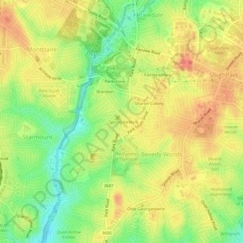
Name: Spring Valley topographic map, elevation, terrain.
Average elevation: 659 ft
Minimum elevation: 545 ft
Maximum elevation: 751 ft
Mecklenburg County trails, hiking, mountain biking, running and outdoor activities
Other topographic maps
Click on a map to view its topography, its elevation and its terrain.
Providence Plantation
United States > North Carolina > Mecklenburg County > Charlotte
Average elevation: 673 ft
Reedy Creek Regional Park
United States > North Carolina > Mecklenburg County > Charlotte
Average elevation: 751 ft
Tuckaseegee Park
United States > North Carolina > Mecklenburg County > Charlotte
Average elevation: 764 ft
Ballantyne's Backyard
United States > North Carolina > Mecklenburg County > Charlotte
Average elevation: 600 ft
Carolina Harbor
United States > North Carolina > Mecklenburg County > Charlotte
Average elevation: 614 ft
Mountainbrook
United States > North Carolina > Mecklenburg County > Charlotte
Average elevation: 663 ft
Providence Plantation
United States > North Carolina > Mecklenburg County > Charlotte
Average elevation: 673 ft
Griffith Lakes
United States > North Carolina > Mecklenburg County > Charlotte
Average elevation: 801 ft
Providence Plantation
United States > North Carolina > Mecklenburg County > Charlotte
Average elevation: 673 ft
Park on Wilgrove
United States > North Carolina > Mecklenburg County > Charlotte > Lakeland Hills
Average elevation: 761 ft