
Make a donation
Gear up for your next adventure:
As an Amazon Associate, this site earns from qualifying purchases at no extra cost to you.
Lac de l'Équerre topographic map
Click on the map to display elevation.
Make a donation
Gear up for your next adventure:
As an Amazon Associate, this site earns from qualifying purchases at no extra cost to you.
About this map
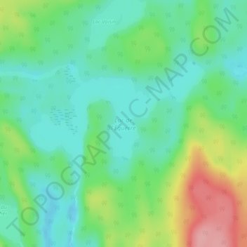
Name: Lac de l'Équerre topographic map, elevation, terrain.
Average elevation: 1,014 ft
Minimum elevation: 879 ft
Maximum elevation: 1,296 ft
Make a donation
Gear up for your next adventure:
As an Amazon Associate, this site earns from qualifying purchases at no extra cost to you.
Other topographic maps
Click on a map to view its topography, its elevation and its terrain.
Mont de la Tête de Brochet
Canada > Quebec > Urban agglomeration of La Tuque > La Tuque
Average elevation: 1,355 ft
Lac Laliberté
Canada > Quebec > Urban agglomeration of La Tuque > La Tuque
Average elevation: 1,440 ft
Make a donation
Gear up for your next adventure:
As an Amazon Associate, this site earns from qualifying purchases at no extra cost to you.
Lac Galarneau
Canada > Quebec > Urban agglomeration of La Tuque > La Tuque
Average elevation: 1,099 ft
Lac Châteauvert
Canada > Quebec > Urban agglomeration of La Tuque > La Tuque
Average elevation: 1,263 ft
Make a donation
Gear up for your next adventure:
As an Amazon Associate, this site earns from qualifying purchases at no extra cost to you.