
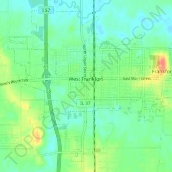
West Frankfort topographic map
Interactive map
Click on the map to display elevation.
About this map
Name: West Frankfort topographic map, elevation, terrain.
Average elevation: 400 ft
Minimum elevation: 354 ft
Maximum elevation: 509 ft
The area of West Frankfort formerly known as Frankfort is still sometimes referred to locally as Frankfort Heights or, more commonly, simply as "The Heights", due to its higher elevation relative to the rest of the city. A post office was maintained in Frankfort Heights until its destruction by fire in 2004, making West Frankfort one of the smallest cities in the United States to have two ZIP codes (the other zip code is designated as "Frankfort Heights, Illinois").
Other topographic maps
Click on a map to view its topography, its elevation and its terrain.
Benton Park
United States > Illinois > Franklin County > Benton
Benton Park, Benton, Franklin County, Illinois, 62897, United States
Average elevation: 453 ft
Benton
United States > Illinois > Franklin County
Benton, Franklin County, Illinois, 62812, United States
Average elevation: 433 ft
Christopher
United States > Illinois > Franklin County
Christopher, Franklin County, Illinois, 62822, United States
Average elevation: 427 ft
Thompsonville
United States > Illinois > Franklin County
Thompsonville, Franklin County, Illinois, United States
Average elevation: 482 ft
Royalton
United States > Illinois > Franklin County > Royalton
Royalton, Franklin County, Illinois, United States
Average elevation: 400 ft
Rend Lake
United States > Illinois > Franklin County
Rend Lake, Franklin County, Illinois, United States
Average elevation: 433 ft