
Make a donation
Gear up for your next adventure:
As an Amazon Associate, this site earns from qualifying purchases at no extra cost to you.
Guys Mills topographic map
Click on the map to display elevation.
Make a donation
Gear up for your next adventure:
As an Amazon Associate, this site earns from qualifying purchases at no extra cost to you.
About this map
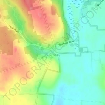
Name: Guys Mills topographic map, elevation, terrain.
Location: Guys Mills, Crawford County, Pennsylvania, United States (41.62673 -79.98391 41.63473 -79.96852)
Average elevation: 1,407 ft
Minimum elevation: 1,306 ft
Maximum elevation: 1,575 ft
Crawford County trails, hiking, mountain biking, running and outdoor activities
Make a donation
Gear up for your next adventure:
As an Amazon Associate, this site earns from qualifying purchases at no extra cost to you.
Other topographic maps
Click on a map to view its topography, its elevation and its terrain.
Espyville
United States > Pennsylvania > Crawford County > Pymatuning Central
Average elevation: 1,047 ft