
Deerwood topographic map
Interactive map
Click on the map to display elevation.
About this map
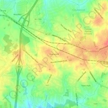
Name: Deerwood topographic map, elevation, terrain.
Average elevation: 722 ft
Minimum elevation: 620 ft
Maximum elevation: 820 ft
Other topographic maps
Click on a map to view its topography, its elevation and its terrain.
Westchester
United States > North Carolina > Mecklenburg County > Charlotte
Westchester, Charlotte, Mecklenburg County, North Carolina, 28130, United States
Average elevation: 761 ft
Beverly Woods East
United States > North Carolina > Mecklenburg County > Charlotte
Beverly Woods East, Charlotte, Mecklenburg County, North Carolina, United States
Average elevation: 666 ft
Coulwood Park
United States > North Carolina > Mecklenburg County > Charlotte > Coulwood Hills
Coulwood Park, Coulwood Hills, Charlotte, Mecklenburg County, North Carolina, 28214, United States
Average elevation: 692 ft
Oakdale Forest
United States > North Carolina > Mecklenburg County > Charlotte
Oakdale Forest, Charlotte, Mecklenburg County, North Carolina, 28130, United States
Average elevation: 745 ft
Yorkmont
United States > North Carolina > Mecklenburg County > Charlotte
Yorkmont, Charlotte, Mecklenburg County, North Carolina, 28217, United States
Average elevation: 689 ft
Fox Run
United States > North Carolina > Mecklenburg County > Charlotte
Fox Run, Charlotte, Mecklenburg County, North Carolina, United States
Average elevation: 689 ft
Mecklenberg Wildlife Club Lake
United States > North Carolina > Mecklenburg County > Charlotte
Mecklenberg Wildlife Club Lake, Charlotte, Mecklenburg County, North Carolina, United States
Average elevation: 702 ft
Hope Farm
United States > North Carolina > Mecklenburg County > Charlotte
Hope Farm, Charlotte, Mecklenburg County, North Carolina, 28214, United States
Average elevation: 656 ft
Charlotte
United States > North Carolina > Mecklenburg County > Charlotte
Charlotte, Mecklenburg County, North Carolina, 28202, United States
Average elevation: 692 ft
Olde Georgetowne
United States > North Carolina > Mecklenburg County > Charlotte
Olde Georgetowne, Charlotte, Mecklenburg County, North Carolina, 28210, United States
Average elevation: 636 ft
Providence
United States > North Carolina > Mecklenburg County > Charlotte
Providence, Charlotte, Mecklenburg County, North Carolina, 28270, United States
Average elevation: 669 ft
Raintree
United States > North Carolina > Mecklenburg County > Charlotte
Raintree, Charlotte, Mecklenburg County, North Carolina, 28226, United States
Average elevation: 617 ft
Carmel Road Park
United States > North Carolina > Mecklenburg County > Charlotte > Carmel Woods
Carmel Road Park, Carmel Woods, Charlotte, Mecklenburg County, North Carolina, 28266, United States
Average elevation: 650 ft
Reedy Creek
United States > North Carolina > Mecklenburg County > Charlotte
Reedy Creek, Charlotte, Mecklenburg County, North Carolina, 28215, United States
Average elevation: 725 ft
Hope Park
United States > North Carolina > Mecklenburg County > Charlotte > Hope Park
Hope Park, Charlotte, Mecklenburg County, North Carolina, 28215, United States
Average elevation: 764 ft
Sharonbrook
United States > North Carolina > Mecklenburg County > Charlotte
Sharonbrook, Charlotte, Mecklenburg County, North Carolina, 28143, United States
Average elevation: 614 ft
Country Roads
United States > North Carolina > Mecklenburg County > Charlotte > Country Roads
Country Roads, Charlotte, Mecklenburg County, North Carolina, 28270, United States
Average elevation: 653 ft