Geolocate

Ithaca topographic map

Click on the map to display elevation.

About this map

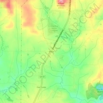
Name: Ithaca topographic map, elevation, terrain.

Location: Ithaca, Carroll County, Georgia, United States (33.66066 -84.96800 33.70066 -84.92800)

Average elevation: 1,122 ft

Minimum elevation: 932 ft

Maximum elevation: 1,345 ft

Carroll County trails, hiking, mountain biking, running and outdoor activities

Other topographic maps

Click on a map to view its topography, its elevation and its terrain.

Mount Zion

United States > Georgia > Carroll County

Average elevation: 1,168 ft

Roopville

United States > Georgia > Carroll County

Average elevation: 1,148 ft

Temple

United States > Georgia > Carroll County

Average elevation: 1,135 ft

Roopville

United States > Georgia > Carroll County

Average elevation: 1,148 ft

Gear up for your next adventure:

👟Men's Trail Runners - Lightweight footwear for fast-paced exploration and light hiking
🦶Hiking Gaiters - Keep debris and water out of your boots
🧤Hiking Gloves - Protective gloves for rugged trails
🔭Telescopic Hiking Pole - Adjustable pole for hiking stability
🏔️Mountain Trail Maps - High‑detail maps for popular peaks

As an Amazon Associate, this site earns from qualifying purchases at no extra cost to you.