
Make a donation
Gear up for your next adventure:
As an Amazon Associate, this site earns from qualifying purchases at no extra cost to you.
Bellevue Hill topographic map
Click on the map to display elevation.
Make a donation
Gear up for your next adventure:
As an Amazon Associate, this site earns from qualifying purchases at no extra cost to you.
About this map
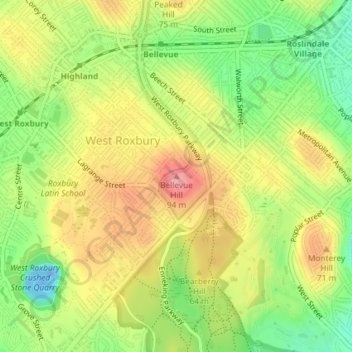
Name: Bellevue Hill topographic map, elevation, terrain.
Average elevation: 167 ft
Minimum elevation: -89 ft
Maximum elevation: 328 ft
Suffolk County trails, hiking, mountain biking, running and outdoor activities
Make a donation
Gear up for your next adventure:
As an Amazon Associate, this site earns from qualifying purchases at no extra cost to you.
Other topographic maps
Click on a map to view its topography, its elevation and its terrain.
Charles River
United States > Massachusetts > Suffolk County > Boston
As native populations were driven out by European settlers, the Charles River became an early center for hydropower and manufacturing in North America. Although in portions of its length, the Charles drops slowly in elevation and has relatively little current, early settlers in Dedham, Massachusetts, found a…
Average elevation: 33 ft
Smith Family Waterfront
United States > Massachusetts > Suffolk County > Boston
Average elevation: 26 ft
Make a donation
Gear up for your next adventure:
As an Amazon Associate, this site earns from qualifying purchases at no extra cost to you.
Make a donation
Gear up for your next adventure:
As an Amazon Associate, this site earns from qualifying purchases at no extra cost to you.
Little Brewster Island
United States > Massachusetts > Suffolk County > Boston
Average elevation: 0 ft