
Great Bircham topographic map
Click on the map to display elevation.
About this map
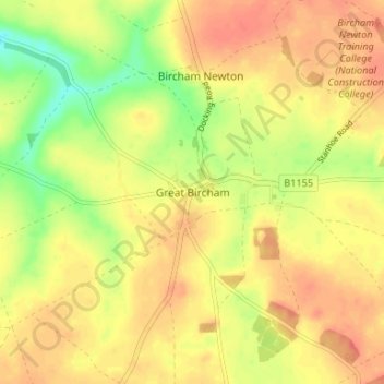
Name: Great Bircham topographic map, elevation, terrain.
Average elevation: 200 ft
Minimum elevation: 105 ft
Maximum elevation: 256 ft
Other topographic maps
Click on a map to view its topography, its elevation and its terrain.
Ringstead
United Kingdom > England > Norfolk > King's Lynn and West Norfolk > Ringstead
Average elevation: 121 ft
Grimston
United Kingdom > England > Norfolk > King's Lynn and West Norfolk > Grimston
Average elevation: 98 ft
Downham Market
United Kingdom > England > Norfolk > King's Lynn and West Norfolk
Average elevation: 66 ft
Terrington St. Clement
United Kingdom > England > Norfolk > King's Lynn and West Norfolk
Average elevation: 7 ft
Burnham Market
United Kingdom > England > Norfolk > King's Lynn and West Norfolk
Average elevation: 144 ft
Terrington St. John
United Kingdom > England > Norfolk > King's Lynn and West Norfolk
Average elevation: 7 ft
Docking
United Kingdom > England > Norfolk > King's Lynn and West Norfolk
Docking village in the centre of the parish is situated at an elevation of 82.7 metres (272 feet), which makes it one of the highest in Norfolk. It is surrounded by arable farmland having little woodland and is a nucleated settlement, with only one historical hamlet associated with it. This is Summerfield to…
Average elevation: 207 ft
Clenchwarton
United Kingdom > England > Norfolk > King's Lynn and West Norfolk > Clenchwarton
Average elevation: 10 ft
Old Hunstanton
United Kingdom > England > Norfolk > King's Lynn and West Norfolk
Average elevation: 56 ft
Stoke Ferry
United Kingdom > England > Norfolk > King's Lynn and West Norfolk
Average elevation: 26 ft
Holme next the Sea
United Kingdom > England > Norfolk > King's Lynn and West Norfolk
Average elevation: 33 ft
Tilney All Saints
United Kingdom > England > Norfolk > King's Lynn and West Norfolk
Average elevation: 10 ft
Bawsey
United Kingdom > England > Norfolk > King's Lynn and West Norfolk > Bawsey
Average elevation: 52 ft
Castle Rising
United Kingdom > England > Norfolk > King's Lynn and West Norfolk > Castle Rising
Average elevation: 72 ft
North Runcton
United Kingdom > England > Norfolk > King's Lynn and West Norfolk
Average elevation: 39 ft
West Winch
United Kingdom > England > Norfolk > King's Lynn and West Norfolk > West Winch
Average elevation: 23 ft
South Creake
United Kingdom > England > Norfolk > King's Lynn and West Norfolk
Average elevation: 177 ft
North Creake
United Kingdom > England > Norfolk > King's Lynn and West Norfolk
Average elevation: 151 ft
Little Massingham
United Kingdom > England > Norfolk > King's Lynn and West Norfolk
Average elevation: 243 ft
Sandringham
United Kingdom > England > Norfolk > King's Lynn and West Norfolk
Average elevation: 26 ft
Syderstone
United Kingdom > England > Norfolk > King's Lynn and West Norfolk > Syderstone
Average elevation: 197 ft
Hockwold cum Wilton
United Kingdom > England > Norfolk > King's Lynn and West Norfolk
Average elevation: 36 ft
Tilney St. Lawrence
United Kingdom > England > Norfolk > King's Lynn and West Norfolk
Average elevation: 7 ft
West Rudham
United Kingdom > England > Norfolk > King's Lynn and West Norfolk
Average elevation: 217 ft
Great Massingham
United Kingdom > England > Norfolk > King's Lynn and West Norfolk
Average elevation: 259 ft
Ingoldisthorpe
United Kingdom > England > Norfolk > King's Lynn and West Norfolk
Average elevation: 72 ft
Hunstanton Beach
United Kingdom > England > Norfolk > King's Lynn and West Norfolk > Hunstanton > Old Hunstanton
Average elevation: 33 ft
Castle Rising
United Kingdom > England > Norfolk > King's Lynn and West Norfolk
Average elevation: 66 ft
Roydon
United Kingdom > England > Norfolk > King's Lynn and West Norfolk > Roydon
Average elevation: 66 ft
Ely-Ouse-Essex Water Transfer Scheme
United Kingdom > England > Norfolk > King's Lynn and West Norfolk > Hockwold cum Wilton
Average elevation: 13 ft
Burnham Overy
United Kingdom > England > Norfolk > King's Lynn and West Norfolk
Average elevation: 20 ft
Hillington
United Kingdom > England > Norfolk > King's Lynn and West Norfolk
Average elevation: 128 ft
Northwold
United Kingdom > England > Norfolk > King's Lynn and West Norfolk > Northwold
Average elevation: 39 ft
Sandringham Estate
United Kingdom > England > Norfolk > King's Lynn and West Norfolk > Sandringham
Average elevation: 82 ft
Walpole Highway
United Kingdom > England > Norfolk > King's Lynn and West Norfolk > Walpole Highway
Average elevation: 7 ft
Ryston
United Kingdom > England > Norfolk > King's Lynn and West Norfolk > Fordham
Average elevation: 49 ft
Runcton Holme
United Kingdom > England > Norfolk > King's Lynn and West Norfolk
Average elevation: 39 ft
Southery
United Kingdom > England > Norfolk > King's Lynn and West Norfolk > Southery
Average elevation: 0 ft
Pur Fleet
United Kingdom > England > Norfolk > King's Lynn and West Norfolk > King's Lynn
Average elevation: 16 ft
Wiggenhall St. Mary Magdalen
United Kingdom > England > Norfolk > King's Lynn and West Norfolk
Average elevation: 3 ft
West Walton
United Kingdom > England > Norfolk > King's Lynn and West Norfolk
Average elevation: 10 ft
Crimplesham
United Kingdom > England > Norfolk > King's Lynn and West Norfolk
Average elevation: 92 ft
Saint Hilary Park
United Kingdom > England > Norfolk > King's Lynn and West Norfolk > King's Lynn
Average elevation: 23 ft
South Wootton
United Kingdom > England > Norfolk > King's Lynn and West Norfolk
Average elevation: 36 ft
Old Bedford River
United Kingdom > England > Norfolk > King's Lynn and West Norfolk
Average elevation: 3 ft
Castle Acre
United Kingdom > England > Norfolk > King's Lynn and West Norfolk
Average elevation: 197 ft
Wiggenhall St. Germans
United Kingdom > England > Norfolk > King's Lynn and West Norfolk
Average elevation: 10 ft
West Winch
United Kingdom > England > Norfolk > King's Lynn and West Norfolk > West Winch
Average elevation: 23 ft
Walpole Highway
United Kingdom > England > Norfolk > King's Lynn and West Norfolk > Walpole Highway
Average elevation: 7 ft
Docking
United Kingdom > England > Norfolk > King's Lynn and West Norfolk
Docking village in the centre of the parish is situated at an elevation of 82.7 metres (272 feet), which makes it one of the highest in Norfolk. It is surrounded by arable farmland having little woodland and is a nucleated settlement, with only one historical hamlet associated with it. This is Summerfield to…
Average elevation: 207 ft
Great Massingham
United Kingdom > England > Norfolk > King's Lynn and West Norfolk
Average elevation: 259 ft
East Walton
United Kingdom > England > Norfolk > King's Lynn and West Norfolk
Average elevation: 79 ft