
Harpley topographic map
Click on the map to display elevation.
About this map
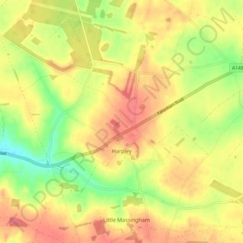
Name: Harpley topographic map, elevation, terrain.
Average elevation: 236 ft
Minimum elevation: 108 ft
Maximum elevation: 328 ft
Other topographic maps
Click on a map to view its topography, its elevation and its terrain.
King's Lynn
United Kingdom > England > Norfolk > King's Lynn and West Norfolk
Average elevation: 23 ft
St John's Fen End
United Kingdom > England > Norfolk > King's Lynn and West Norfolk
Average elevation: 3 ft
Brandon Bank
United Kingdom > England > Norfolk > King's Lynn and West Norfolk > Feltwell
Average elevation: -3 ft
Great Bircham
United Kingdom > England > Norfolk > King's Lynn and West Norfolk
Average elevation: 200 ft
Bircham Tofts
United Kingdom > England > Norfolk > King's Lynn and West Norfolk > Great Bircham
Average elevation: 207 ft
Brancaster Staithe
United Kingdom > England > Norfolk > King's Lynn and West Norfolk
Average elevation: 59 ft
Methwold Hythe
United Kingdom > England > Norfolk > King's Lynn and West Norfolk > Methwold
Average elevation: 26 ft
Flaxley
United Kingdom > England > Norfolk > King's Lynn and West Norfolk > Holme next the Sea
Average elevation: 26 ft
Old Hunstanton Lighthouse
United Kingdom > England > Norfolk > King's Lynn and West Norfolk > Hunstanton > Old Hunstanton
Average elevation: 30 ft
Walpole St Andrew
United Kingdom > England > Norfolk > King's Lynn and West Norfolk
Average elevation: 10 ft
Ely-Ouse-Essex Water Transfer Scheme
United Kingdom > England > Norfolk > King's Lynn and West Norfolk > Hockwold cum Wilton
Average elevation: 13 ft
St John's Highway
United Kingdom > England > Norfolk > King's Lynn and West Norfolk
Average elevation: 7 ft
Sandringham Estate
United Kingdom > England > Norfolk > King's Lynn and West Norfolk > Sandringham
Average elevation: 82 ft
Walton Highway
United Kingdom > England > Norfolk > King's Lynn and West Norfolk
Average elevation: 10 ft
Castle Rising
United Kingdom > England > Norfolk > King's Lynn and West Norfolk > Castle Rising
Average elevation: 72 ft
Denver Sluice
United Kingdom > England > Norfolk > King's Lynn and West Norfolk > Downham Market
Average elevation: 7 ft
Marshland St James
United Kingdom > England > Norfolk > King's Lynn and West Norfolk
Average elevation: 3 ft
Pott Row
United Kingdom > England > Norfolk > King's Lynn and West Norfolk > Pott Row
Average elevation: 59 ft
Saint Hilary Park
United Kingdom > England > Norfolk > King's Lynn and West Norfolk > King's Lynn
Average elevation: 23 ft
West Bilney
United Kingdom > England > Norfolk > King's Lynn and West Norfolk
Average elevation: 46 ft
Pur Fleet
United Kingdom > England > Norfolk > King's Lynn and West Norfolk > King's Lynn
Average elevation: 16 ft
Bircham Newton
United Kingdom > England > Norfolk > King's Lynn and West Norfolk
Average elevation: 203 ft
Suspension Bridge
United Kingdom > England > Norfolk > King's Lynn and West Norfolk > Welney > Suspension Bridge
Average elevation: 3 ft
Old Bedford River
United Kingdom > England > Norfolk > King's Lynn and West Norfolk
Average elevation: 3 ft
King's Lynn
United Kingdom > England > Norfolk > King's Lynn and West Norfolk
Average elevation: 23 ft