Geolocate

Marissa topographic map

Click on the map to display elevation.

About this map

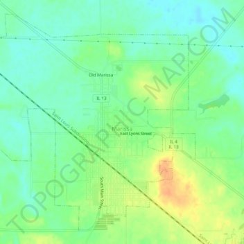
Name: Marissa topographic map, elevation, terrain.

Location: Marissa, Saint Clair County, Illinois, United States (38.23436 -89.78359 38.26776 -89.73569)

Average elevation: 453 ft

Minimum elevation: 400 ft

Maximum elevation: 531 ft

Saint Clair County trails, hiking, mountain biking, running and outdoor activities

Other topographic maps

Click on a map to view its topography, its elevation and its terrain.

Roachtown

United States > Illinois > Saint Clair County

Average elevation: 538 ft

Westview

United States > Illinois > Saint Clair County

Average elevation: 489 ft

Shiloh

United States > Illinois > Saint Clair County > Shiloh > Shiloh

Average elevation: 518 ft

Gear up for your next adventure:

🧣Hiking Neck Gaiter - Multi‑use neck protection for outdoor weather
🪵Folding Camp Saw - Compact saw for wood and campsite work
🎁Geography Themed Gifts - Unique gift ideas for map lovers and geography enthusiasts
🩹Survival Bandages - High‑quality bandages for emergencies
📻Weather Alert Radios - Stay informed of storm risks while off-the-grid

As an Amazon Associate, this site earns from qualifying purchases at no extra cost to you.