Geolocate

Craig Beach topographic map

Click on the map to display elevation.

About this map

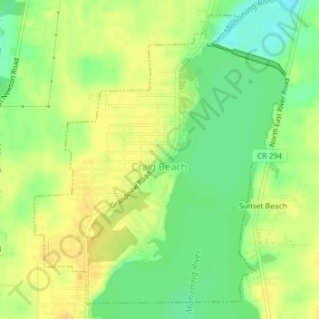
Name: Craig Beach topographic map, elevation, terrain.

Location: Craig Beach, Mahoning County, Ohio, United States (41.10527 -80.99746 41.12983 -80.96926)

Average elevation: 961 ft

Minimum elevation: 909 ft

Maximum elevation: 994 ft

Mahoning County trails, hiking, mountain biking, running and outdoor activities

Other topographic maps

Click on a map to view its topography, its elevation and its terrain.

Beaver Island

United States > Ohio > Mahoning County > Boardman

Average elevation: 1,076 ft

Herbert Corners

United States > Ohio > Mahoning County

Average elevation: 1,129 ft

Misner Corners

United States > Ohio > Mahoning County

Average elevation: 1,073 ft

Damascus

United States > Ohio > Mahoning County

Average elevation: 1,207 ft

New Albany

United States > Ohio > Mahoning County

Average elevation: 1,142 ft

Paradise

United States > Ohio > Mahoning County > Paradise

Average elevation: 1,096 ft

Ellsworth

United States > Ohio > Mahoning County

Average elevation: 1,053 ft

North Lima

United States > Ohio > Mahoning County > North Lima

Average elevation: 1,099 ft

North Jackson

United States > Ohio > Mahoning County

Average elevation: 1,020 ft

Ginger Hill

United States > Ohio > Mahoning County > New Middletown

Average elevation: 1,188 ft

Gear up for your next adventure:

🔌Solar Panel Charger - Charge gear sustainably outdoors
🔭Stargazing Telescopes - Perfect for camping in low-light pollution areas shown on maps
🪶Wildlife Field Guides - Learn animal tracking and species ID
🥇GPS Hiking Watch - Multi‑sport GPS watch with navigation and trail tracking
🧣Hiking Neck Gaiter - Multi‑use neck protection for outdoor weather

As an Amazon Associate, this site earns from qualifying purchases at no extra cost to you.