Geolocate

Mignon topographic map

Click on the map to display elevation.

About this map

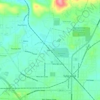
Name: Mignon topographic map, elevation, terrain.

Location: Mignon, Talladega County, Alabama, 35150, United States (33.16345 -86.28109 33.20345 -86.24109)

Average elevation: 564 ft

Minimum elevation: 459 ft

Maximum elevation: 879 ft

Talladega County trails, hiking, mountain biking, running and outdoor activities

Other topographic maps

Click on a map to view its topography, its elevation and its terrain.

Talladega

United States > Alabama > Talladega County

Average elevation: 627 ft

Waldo

United States > Alabama > Talladega County

Average elevation: 748 ft

Oak Grove

United States > Alabama > Talladega County

Average elevation: 574 ft

Munford

United States > Alabama > Talladega County

Average elevation: 627 ft

Oxford

United States > Alabama > Talladega County > Oxford

Average elevation: 607 ft

Childersburg

United States > Alabama > Talladega County

Average elevation: 479 ft

Lincoln

United States > Alabama > Talladega County

Average elevation: 554 ft

Oxford

United States > Alabama > Talladega County

Average elevation: 646 ft

Gear up for your next adventure:

🪶Camping Sleeping Pad - Comfortable sleeping pad for backpacking
🧭Outdoor Navigation Book - Learn advanced navigation skills
🍳Camping Cook Set - Complete cookware for outdoor meals
🪶Trail Camera - Capture wildlife on your hikes
🥾Hiking Shoes - Durable and comfortable shoes for trail hiking

As an Amazon Associate, this site earns from qualifying purchases at no extra cost to you.