
Make a donation
Gear up for your next adventure:
As an Amazon Associate, this site earns from qualifying purchases at no extra cost to you.
Setsoto Local Municipality topographic map
Click on the map to display elevation.
Make a donation
Gear up for your next adventure:
As an Amazon Associate, this site earns from qualifying purchases at no extra cost to you.
About this map
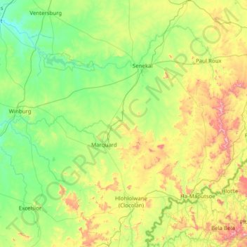
Name: Setsoto Local Municipality topographic map, elevation, terrain.
Average elevation: 5,095 ft
Minimum elevation: 4,285 ft
Maximum elevation: 7,772 ft
Make a donation
Gear up for your next adventure:
As an Amazon Associate, this site earns from qualifying purchases at no extra cost to you.
Other topographic maps
Click on a map to view its topography, its elevation and its terrain.
Clarens
South Africa > Free State > Thabo Mofutsanyana District Municipality > Dihlabeng Local Municipality
Average elevation: 6,148 ft
Phuthaditjhaba
South Africa > Free State > Thabo Mofutsanyana District Municipality > Maluti-a-Phofung Local Municipality
Average elevation: 5,696 ft
Bohlokong
South Africa > Free State > Thabo Mofutsanyana District Municipality > Dihlabeng Local Municipality
Average elevation: 5,358 ft
Ficksburg
South Africa > Free State > Thabo Mofutsanyana District Municipality > Setsoto Local Municipality
Average elevation: 5,305 ft
Make a donation
Gear up for your next adventure:
As an Amazon Associate, this site earns from qualifying purchases at no extra cost to you.
Bethlehem
South Africa > Free State > Thabo Mofutsanyana District Municipality > Dihlabeng Local Municipality
The city lies at an altitude of 1,700 metres (5,600 ft) and this contributes to its cool climate with frosty winters and mild summers. The average annual temperature is around 14 °C (57 °F).
Average elevation: 5,495 ft
Vrede
South Africa > Free State > Thabo Mofutsanyana District Municipality > Phumelela Local Municipality
Average elevation: 5,505 ft
Mont Pelaan
South Africa > Free State > Thabo Mofutsanyana District Municipality > Phumelela Local Municipality
Average elevation: 6,430 ft
Hlohlolwane (Clocolan)
South Africa > Free State > Thabo Mofutsanyana District Municipality > Setsoto Local Municipality
Average elevation: 5,226 ft
Make a donation
Gear up for your next adventure:
As an Amazon Associate, this site earns from qualifying purchases at no extra cost to you.
Ladybrand
South Africa > Free State > Thabo Mofutsanyana District Municipality > Mantsopa Local Municipality
Average elevation: 5,361 ft
Fouriesburg
South Africa > Free State > Thabo Mofutsanyana District Municipality > Dihlabeng Local Municipality
Average elevation: 5,725 ft
Renoster River
South Africa > Free State > Thabo Mofutsanyana District Municipality > Nketoana Local Municipality
Average elevation: 5,207 ft
Reitz
South Africa > Free State > Thabo Mofutsanyana District Municipality > Nketoana Local Municipality
Reitz is located in the north-eastern part of the Free State province, 300 kilometres (190 mi) north-east of Bloemfontein and 180 kilometres (110 mi) south of Johannesburg. It lies roughly halfway between the towns of Bethlehem and Frankfort, at an elevation of 1,630 metres (5,350 ft).
Average elevation: 5,407 ft
Make a donation
Gear up for your next adventure:
As an Amazon Associate, this site earns from qualifying purchases at no extra cost to you.
Swartkrans
South Africa > Free State > Thabo Mofutsanyana District Municipality > Dihlabeng Local Municipality
Average elevation: 6,680 ft
Marquard
South Africa > Free State > Thabo Mofutsanyana District Municipality > Setsoto Local Municipality
Average elevation: 4,961 ft
Wilge River
South Africa > Free State > Thabo Mofutsanyana District Municipality > Maluti-a-Phofung Local Municipality
Average elevation: 5,705 ft
Koeberg
South Africa > Free State > Thabo Mofutsanyana District Municipality > Dihlabeng Local Municipality
Average elevation: 7,110 ft
Make a donation
Gear up for your next adventure:
As an Amazon Associate, this site earns from qualifying purchases at no extra cost to you.
Mabula
South Africa > Free State > Thabo Mofutsanyana District Municipality > Mantsopa Local Municipality
Average elevation: 5,794 ft
Mount Morkel
South Africa > Free State > Thabo Mofutsanyana District Municipality > Dihlabeng Local Municipality
Average elevation: 6,066 ft
Elands River
South Africa > Free State > Thabo Mofutsanyana District Municipality > Maluti-a-Phofung Local Municipality
Average elevation: 5,374 ft
Driekloof Dam
South Africa > Free State > Thabo Mofutsanyana District Municipality > Maluti-a-Phofung Local Municipality
Average elevation: 5,719 ft
Make a donation
Gear up for your next adventure:
As an Amazon Associate, this site earns from qualifying purchases at no extra cost to you.
Sterkfontein Dam
South Africa > Free State > Thabo Mofutsanyana District Municipality > Maluti-a-Phofung Local Municipality
Average elevation: 5,502 ft
Renoster River
South Africa > Free State > Thabo Mofutsanyana District Municipality > Nketoana Local Municipality > Petrus Steyn
Average elevation: 5,571 ft
Ficksburg
South Africa > Free State > Thabo Mofutsanyana District Municipality > Setsoto Local Municipality
Average elevation: 5,305 ft
Rainfall Dam
South Africa > Free State > Thabo Mofutsanyana District Municipality > Maluti-a-Phofung Local Municipality
Average elevation: 5,600 ft
Make a donation
Gear up for your next adventure:
As an Amazon Associate, this site earns from qualifying purchases at no extra cost to you.
iNtabazwe (Harrismith)
South Africa > Free State > Thabo Mofutsanyana District Municipality > Maluti-a-Phofung Local Municipality
Average elevation: 5,630 ft
Senekal
South Africa > Free State > Thabo Mofutsanyana District Municipality > Setsoto Local Municipality
Average elevation: 4,760 ft
Petrus Steyn
South Africa > Free State > Thabo Mofutsanyana District Municipality > Nketoana Local Municipality
Average elevation: 5,538 ft
Bethlehem
South Africa > Free State > Thabo Mofutsanyana District Municipality > Dihlabeng Local Municipality
The city lies at an altitude of 1,700 metres (5,600 ft) and this contributes to its cool climate with frosty winters and mild summers. The average annual temperature is around 14 °C (57 °F).
Average elevation: 5,495 ft
Make a donation
Gear up for your next adventure:
As an Amazon Associate, this site earns from qualifying purchases at no extra cost to you.
Mabula
South Africa > Free State > Thabo Mofutsanyana District Municipality > Mantsopa Local Municipality
Average elevation: 5,794 ft
Marquard
South Africa > Free State > Thabo Mofutsanyana District Municipality > Setsoto Local Municipality
Average elevation: 4,961 ft
Bethlehem
South Africa > Free State > Thabo Mofutsanyana District Municipality > Dihlabeng Local Municipality
The city lies at an altitude of 1,700 metres (5,600 ft) and this contributes to its cool climate with frosty winters and mild summers. The average annual temperature is around 14 °C (57 °F).
Average elevation: 5,495 ft
Hobhouse
South Africa > Free State > Thabo Mofutsanyana District Municipality > Mantsopa Local Municipality
Average elevation: 4,902 ft
Make a donation
Gear up for your next adventure:
As an Amazon Associate, this site earns from qualifying purchases at no extra cost to you.
Paul Roux
South Africa > Free State > Thabo Mofutsanyana District Municipality > Dihlabeng Local Municipality
Average elevation: 5,184 ft
Ladybrand
South Africa > Free State > Thabo Mofutsanyana District Municipality > Mantsopa Local Municipality
Average elevation: 5,361 ft
Meqheleng
South Africa > Free State > Thabo Mofutsanyana District Municipality > Setsoto Local Municipality
Average elevation: 5,246 ft
Hlohlolwane (Clocolan)
South Africa > Free State > Thabo Mofutsanyana District Municipality > Setsoto Local Municipality
Average elevation: 5,226 ft
Make a donation
Gear up for your next adventure:
As an Amazon Associate, this site earns from qualifying purchases at no extra cost to you.
Clarens
South Africa > Free State > Thabo Mofutsanyana District Municipality > Dihlabeng Local Municipality
Average elevation: 6,148 ft
Elands River
South Africa > Free State > Thabo Mofutsanyana District Municipality > Maluti-a-Phofung Local Municipality
Average elevation: 5,374 ft
Memel
South Africa > Free State > Thabo Mofutsanyana District Municipality > Phumelela Local Municipality
Memel-Zamani lies in the west-facing lee of the Drakensberg escarpment, the escarpment functioning as the continental divide. Its high elevation and close proximity to the escarpment are the major reason for Memel's cold winters. Visitors are frequently surprised by just how cold winter can be in Memel. Added…
Average elevation: 5,653 ft
Rainfall Dam
South Africa > Free State > Thabo Mofutsanyana District Municipality > Maluti-a-Phofung Local Municipality
Average elevation: 5,600 ft
Make a donation
Gear up for your next adventure:
As an Amazon Associate, this site earns from qualifying purchases at no extra cost to you.
Fouriesburg
South Africa > Free State > Thabo Mofutsanyana District Municipality > Dihlabeng Local Municipality
Average elevation: 5,725 ft
Rainfall Dam
South Africa > Free State > Thabo Mofutsanyana District Municipality > Maluti-a-Phofung Local Municipality
Average elevation: 5,600 ft
Reitz
South Africa > Free State > Thabo Mofutsanyana District Municipality > Nketoana Local Municipality
Reitz is located in the north-eastern part of the Free State province, 300 kilometres (190 mi) north-east of Bloemfontein and 180 kilometres (110 mi) south of Johannesburg. It lies roughly halfway between the towns of Bethlehem and Frankfort, at an elevation of 1,630 metres (5,350 ft).
Average elevation: 5,407 ft
Rainfall Dam
South Africa > Free State > Thabo Mofutsanyana District Municipality > Maluti-a-Phofung Local Municipality
Average elevation: 5,600 ft
Make a donation
Gear up for your next adventure:
As an Amazon Associate, this site earns from qualifying purchases at no extra cost to you.
Phuthaditjhaba
South Africa > Free State > Thabo Mofutsanyana District Municipality > Maluti-a-Phofung Local Municipality
Average elevation: 5,696 ft