Geolocate

Bonham topographic map

Click on the map to display elevation.

About this map

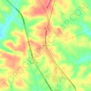
Name: Bonham topographic map, elevation, terrain.

Location: Bonham, Union County, South Carolina, United States (34.75680 -81.66649 34.79680 -81.62649)

Average elevation: 630 ft

Minimum elevation: 492 ft

Maximum elevation: 741 ft

Union County trails, hiking, mountain biking, running and outdoor activities

Other topographic maps

Click on a map to view its topography, its elevation and its terrain.

Jonesville

United States > South Carolina > Union County

Average elevation: 636 ft

Carlisle

United States > South Carolina > Union County

Average elevation: 443 ft

Gear up for your next adventure:

🧭Hiking Compass - Precision compass for reliable navigation in the wilderness
🔦Compact Flashlight - Reliable flashlight for emergencies
🔭Compact Binoculars - HD vision for scouting terrain and identifying distant landmarks
🧭GPS Watch Accessories - Bands and chargers for GPS watches
🏫Relief Map Kits - Hands-on tools for teaching landforms and elevation

As an Amazon Associate, this site earns from qualifying purchases at no extra cost to you.