
Make a donation
Gear up for your next adventure:
As an Amazon Associate, this site earns from qualifying purchases at no extra cost to you.
Sayabec topographic map
Click on the map to display elevation.
Make a donation
Gear up for your next adventure:
As an Amazon Associate, this site earns from qualifying purchases at no extra cost to you.
Sayabec
The geography of Sayabec is located in the mountains range of the Appalachian on a side of Chic-Choc Mountains in the section of Notre Dame Mountains. It is at an altitude of 200 m and the summits reach 350 m.
Make a donation
Gear up for your next adventure:
As an Amazon Associate, this site earns from qualifying purchases at no extra cost to you.
About this map
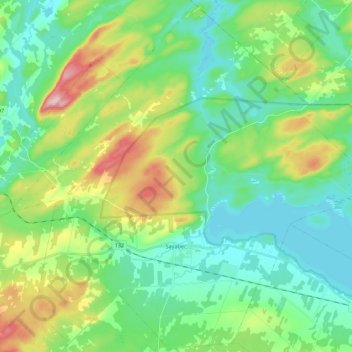
Name: Sayabec topographic map, elevation, terrain.
Average elevation: 732 ft
Minimum elevation: 502 ft
Maximum elevation: 1,322 ft
Make a donation
Gear up for your next adventure:
As an Amazon Associate, this site earns from qualifying purchases at no extra cost to you.
Other topographic maps
Click on a map to view its topography, its elevation and its terrain.