Geolocate

Bicknor topographic map

Click on the map to display elevation.

About this map

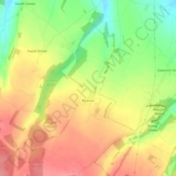
Name: Bicknor topographic map, elevation, terrain.

Location: Bicknor, Maidstone, Kent, England, United Kingdom (51.28545 0.65484 51.31017 0.68047)

Average elevation: 466 ft

Minimum elevation: 299 ft

Maximum elevation: 594 ft

Other topographic maps

Click on a map to view its topography, its elevation and its terrain.

Westfield Sole

United Kingdom > England > Kent > Maidstone

Average elevation: 476 ft

Detling Hill

United Kingdom > England > Kent > Maidstone

Average elevation: 499 ft

Mote Park

United Kingdom > England > Kent > Maidstone > Otham

Average elevation: 171 ft

Broomfield

United Kingdom > England > Kent > Maidstone > Leeds

Average elevation: 315 ft

Lenham Heath

United Kingdom > England > Kent > Maidstone

Average elevation: 315 ft

Leadingcross Green

United Kingdom > England > Kent > Maidstone > Lenham

Average elevation: 387 ft

Walderslade Woods

United Kingdom > England > Kent > Maidstone

Average elevation: 509 ft

Harpole

United Kingdom > England > Kent > Maidstone > Detling

Average elevation: 338 ft

Bletchenden

United Kingdom > England > Kent > Maidstone > Headcorn

Average elevation: 79 ft

Liverton Street

United Kingdom > England > Kent > Maidstone > Grafty Green

Average elevation: 335 ft

Linton

United Kingdom > England > Kent > Maidstone

Average elevation: 233 ft

East Lenham

United Kingdom > England > Kent > Maidstone > Lenham

Average elevation: 417 ft

Bicknor Wood

United Kingdom > England > Kent > Maidstone > Otham

Average elevation: 279 ft

Laddingford

United Kingdom > England > Kent > Maidstone > Yalding

Average elevation: 46 ft

Langley Park

United Kingdom > England > Kent > Maidstone > Langley

Average elevation: 315 ft

Bletchingly

United Kingdom > England > Kent > Maidstone

Average elevation: 121 ft

Weavering Park

United Kingdom > England > Kent > Maidstone > Grove Green

Average elevation: 184 ft

Eyhorne Street

United Kingdom > England > Kent > Maidstone > Hollingbourne

Average elevation: 295 ft

Kingswood

United Kingdom > England > Kent > Maidstone

Average elevation: 358 ft

Gear up for your next adventure:

📡Handheld GPS Device - Reliable handheld GPS for outdoor navigation
🍳Camping Cook Set - Complete cookware for outdoor meals
🧴Hand Sanitizer - Keep hands clean while hiking
👖Convertible Hiking Pants - Versatile zip-off pants for changing altitudes and temperatures
🏫Relief Map Kits - Hands-on tools for teaching landforms and elevation

As an Amazon Associate, this site earns from qualifying purchases at no extra cost to you.