Geolocate

Nhc topographic map

Click on the map to display elevation.

About this map

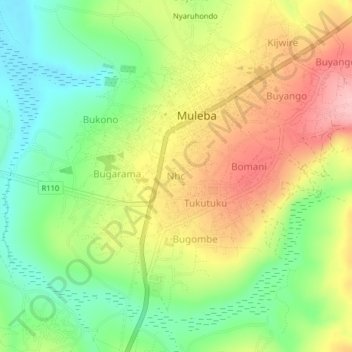
Name: Nhc topographic map, elevation, terrain.

Location: Nhc, Muleba, Kagera, Lake Zone, Tanzania (-1.86861 31.63257 -1.82861 31.67257)

Average elevation: 4,094 ft

Minimum elevation: 3,845 ft

Maximum elevation: 4,396 ft

Other topographic maps

Click on a map to view its topography, its elevation and its terrain.

Muleba

Tanzania > Kagera

Average elevation: 4,121 ft

Bukoba

Tanzania > Kagera

Average elevation: 3,990 ft

Karagwe

Tanzania > Kagera

Average elevation: 4,442 ft

Kibeta

Tanzania > Kagera

Average elevation: 4,137 ft

Karagwe

Tanzania > Kagera

Average elevation: 4,442 ft

Karagwe

Tanzania > Kagera

Average elevation: 4,442 ft

Gear up for your next adventure:

🪶Paracord Bracelet - Survival bracelet with built‑in tools
🔌Solar Panel Charger - Charge gear sustainably outdoors
📱Solar Portable Charger - Solar power bank for charging devices off‑grid
🦶Carbon Trekking Poles - Reduce knee impact on steep descents with ultra-light poles
🌡️Handheld Weather Meters - Measure wind, temp, and pressure for safe mountain travel

As an Amazon Associate, this site earns from qualifying purchases at no extra cost to you.