Geolocate

Passi topographic map

Click on the map to display elevation.

About this map

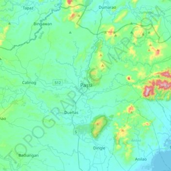
Name: Passi topographic map, elevation, terrain.

Location: Passi, Iloilo, Western Visayas, 5037, Philippines (10.95735 122.48687 11.27735 122.80687)

Average elevation: 266 ft

Minimum elevation: 0 ft

Maximum elevation: 1,847 ft

Other topographic maps

Click on a map to view its topography, its elevation and its terrain.

Balasan

Philippines > Iloilo

Average elevation: 138 ft

Banate

Philippines > Iloilo

Average elevation: 112 ft

Miagao

Philippines > Iloilo

Average elevation: 318 ft

Lambunao

Philippines > Iloilo > Lambunao

Average elevation: 417 ft

Anilao

Philippines > Iloilo > Anilao

Average elevation: 171 ft

Bayas Island

Philippines > Iloilo > Estancia > Bayas

Average elevation: 3 ft

Balbagon Island

Philippines > Iloilo > Carles

Average elevation: 0 ft

Leganes

Philippines > Iloilo

Average elevation: 26 ft

Gear up for your next adventure:

📖Nature Tracking Books - Learn to track wildlife and terrain
🛏️Cold Weather Sleeping Bag - Warm sleeping bag for cold conditions
🏫Relief Map Kits - Hands-on tools for teaching landforms and elevation
🧴Hand Sanitizer - Keep hands clean while hiking
🥤Water Filter Bottle - All‑in‑one filter bottle for safe hydration

As an Amazon Associate, this site earns from qualifying purchases at no extra cost to you.