
Cyclone topographic map
Click on the map to display elevation.
About this map
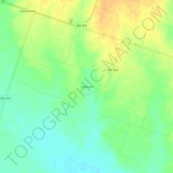
Name: Cyclone topographic map, elevation, terrain.
Location: Cyclone, Bell County, Texas, United States (31.00768 -97.17083 31.04768 -97.13083)
Average elevation: 472 ft
Minimum elevation: 423 ft
Maximum elevation: 525 ft
Bell County trails, hiking, mountain biking, running and outdoor activities
Other topographic maps
Click on a map to view its topography, its elevation and its terrain.
Belton
United States > Texas > Bell County
Belton is located 60 miles (97 km) north of Austin, 137 miles (220 km) south of Dallas, and 184 miles (296 km) west of Houston. It is near the center of Bell County at 31°3′32″N 97°27′48″W / 31.05889°N 97.46333°W / 31.05889; -97.46333 (31.058904, –97.463382). Belton is at the point where…
Average elevation: 587 ft
La Quinta Inn Killeen - Fort Hood
United States > Texas > Bell County > Killeen
Average elevation: 889 ft