Geolocate

Temple topographic map

Click on the map to display elevation.

About this map

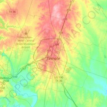
Name: Temple topographic map, elevation, terrain.

Location: Temple, Bell County, Texas, United States (31.00815 -97.55804 31.20906 -97.29137)

Average elevation: 610 ft

Minimum elevation: 446 ft

Maximum elevation: 843 ft

Bell County trails, hiking, mountain biking, running and outdoor activities

Other topographic maps

Click on a map to view its topography, its elevation and its terrain.

Rogers

United States > Texas > Bell County

Average elevation: 522 ft

Bland Mountain

United States > Texas > Bell County

Average elevation: 630 ft

Zabcikville

United States > Texas > Bell County

Average elevation: 489 ft

Youngsport

United States > Texas > Bell County

Average elevation: 741 ft

White Hall

United States > Texas > Bell County

Average elevation: 692 ft

Vilas

United States > Texas > Bell County

Average elevation: 479 ft

Union Grove

United States > Texas > Bell County

Average elevation: 715 ft

Summers Mill

United States > Texas > Bell County

Average elevation: 528 ft

Stampede

United States > Texas > Bell County

Average elevation: 689 ft

Sparks

United States > Texas > Bell County

Average elevation: 489 ft

Seaton

United States > Texas > Bell County

Average elevation: 492 ft

Red Ranger

United States > Texas > Bell County

Average elevation: 456 ft

Prairie Dell

United States > Texas > Bell County

Average elevation: 778 ft

Ratibor

United States > Texas > Bell County

Average elevation: 515 ft

Owl Creek

United States > Texas > Bell County

Average elevation: 669 ft

Oscar

United States > Texas > Bell County

Average elevation: 512 ft

New Colony

United States > Texas > Bell County

Average elevation: 440 ft

Moffat

United States > Texas > Bell County

Average elevation: 669 ft

Meeks

United States > Texas > Bell County

Average elevation: 440 ft

Maxdale

United States > Texas > Bell County

Average elevation: 810 ft

Leedale

United States > Texas > Bell County

Average elevation: 482 ft

Joe Lee

United States > Texas > Bell County

Average elevation: 486 ft

Heidenheimer

United States > Texas > Bell County

Average elevation: 531 ft

Edgeworth

United States > Texas > Bell County

Average elevation: 420 ft

Little River-Academy

United States > Texas > Bell County

Average elevation: 502 ft

Pendleton

United States > Texas > Bell County

Average elevation: 768 ft

Airville

United States > Texas > Bell County

Average elevation: 528 ft

Belfalls

United States > Texas > Bell County

Average elevation: 554 ft

Cyclone

United States > Texas > Bell County

Average elevation: 472 ft

Ding Dong

United States > Texas > Bell County

Average elevation: 791 ft

Salado

United States > Texas > Bell County

Average elevation: 643 ft

Smith

United States > Texas > Bell County > Temple

Average elevation: 630 ft

Holland

United States > Texas > Bell County

Average elevation: 545 ft

Lone Star

United States > Texas > Bell County > Killeen

Average elevation: 820 ft

Troy

United States > Texas > Bell County

Average elevation: 696 ft

Cedar Valley

United States > Texas > Bell County

Average elevation: 860 ft

Killeen

United States > Texas > Bell County > Killeen

Average elevation: 843 ft

Gear up for your next adventure:

🪶Camp Gear Gift Set - Perfect gift bundle for outdoor fans
📷Action Cameras - Rugged cameras to document your journeys across rugged terrain
🛰️Satellite Messengers - Emergency SOS and two-way messaging for off-grid adventures
🧯Emergency Survival Kit - All‑in‑one survival essentials for the backcountry
📱Heavy-Duty Phone Cases - Drop-proof and waterproof protection for outdoor navigation

As an Amazon Associate, this site earns from qualifying purchases at no extra cost to you.