
Thank you for supporting this site ❤️
Make a donation
Make a donation
Gear up for your next adventure:
As an Amazon Associate, this site earns from qualifying purchases at no extra cost to you.
Hollersbach topographic map
Click on the map to display elevation.
Thank you for supporting this site ❤️
Make a donation
Make a donation
Gear up for your next adventure:
As an Amazon Associate, this site earns from qualifying purchases at no extra cost to you.
About this map
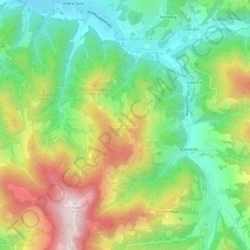
Name: Hollersbach topographic map, elevation, terrain.
Average elevation: 2,789 ft
Minimum elevation: 1,988 ft
Maximum elevation: 4,012 ft
Thank you for supporting this site ❤️
Make a donation
Make a donation
Gear up for your next adventure:
As an Amazon Associate, this site earns from qualifying purchases at no extra cost to you.
Other topographic maps
Click on a map to view its topography, its elevation and its terrain.
Grüner See
Oostenrijk > Stiermarken > Bezirk Bruck-Mürzzuschlag > Tragöß-Sankt Katharein
Average elevation: 3,504 ft