
Make a donation
Gear up for your next adventure:
As an Amazon Associate, this site earns from qualifying purchases at no extra cost to you.
Engstingen topographic map
Click on the map to display elevation.
Make a donation
Gear up for your next adventure:
As an Amazon Associate, this site earns from qualifying purchases at no extra cost to you.
Engstingen
Engstingen liegt am Nordrand der Schwäbischen Alb im Bereich der Mittleren Kuppenalb, in 680 bis 750 Meter Höhe auf der Albhochfläche oberhalb des Albtraufs. Es liegt im Tal der Ur-Lauter, etwa 15 km Luftlinie südlich der Kreisstadt Reutlingen.
Make a donation
Gear up for your next adventure:
As an Amazon Associate, this site earns from qualifying purchases at no extra cost to you.
About this map
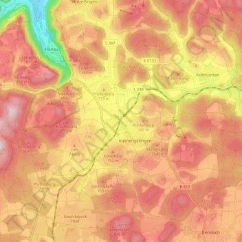
Name: Engstingen topographic map, elevation, terrain.
Average elevation: 2,411 ft
Minimum elevation: 1,680 ft
Maximum elevation: 2,815 ft
Make a donation
Gear up for your next adventure:
As an Amazon Associate, this site earns from qualifying purchases at no extra cost to you.
Other topographic maps
Click on a map to view its topography, its elevation and its terrain.
Gönningen
Deutschland > Baden-Württemberg > Landkreis Reutlingen > Reutlingen
Average elevation: 1,995 ft
Oberwilzingen
Deutschland > Baden-Württemberg > Landkreis Reutlingen > Hayingen
Average elevation: 2,090 ft
Bronnweiler
Deutschland > Baden-Württemberg > Landkreis Reutlingen > Reutlingen
Average elevation: 1,706 ft
Make a donation
Gear up for your next adventure:
As an Amazon Associate, this site earns from qualifying purchases at no extra cost to you.
Mörsingen
Deutschland > Baden-Württemberg > Landkreis Reutlingen > Mörsingen
Average elevation: 2,182 ft
Böhringen
Deutschland > Baden-Württemberg > Landkreis Reutlingen > Römerstein
Average elevation: 2,543 ft