
Make a donation
Gear up for your next adventure:
As an Amazon Associate, this site earns from qualifying purchases at no extra cost to you.
Römerstein topographic map
Click on the map to display elevation.
Make a donation
Gear up for your next adventure:
As an Amazon Associate, this site earns from qualifying purchases at no extra cost to you.
About this map
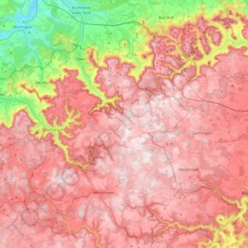
Name: Römerstein topographic map, elevation, terrain.
Average elevation: 2,119 ft
Minimum elevation: 869 ft
Maximum elevation: 2,848 ft
Make a donation
Gear up for your next adventure:
As an Amazon Associate, this site earns from qualifying purchases at no extra cost to you.
Other topographic maps
Click on a map to view its topography, its elevation and its terrain.
Engstingen
Deutschland > Baden-Württemberg > Landkreis Reutlingen
Engstingen liegt am Nordrand der Schwäbischen Alb im Bereich der Mittleren Kuppenalb, in 680 bis 750 Meter Höhe auf der Albhochfläche oberhalb des Albtraufs. Es liegt im Tal der Ur-Lauter, etwa 15 km Luftlinie südlich der Kreisstadt Reutlingen.
Average elevation: 2,411 ft
Mägerkingen
Deutschland > Baden-Württemberg > Landkreis Reutlingen > Trochtelfingen
Average elevation: 2,493 ft
Pfullingen
Deutschland > Baden-Württemberg > Landkreis Reutlingen > Pfullingen
Average elevation: 1,854 ft
Make a donation
Gear up for your next adventure:
As an Amazon Associate, this site earns from qualifying purchases at no extra cost to you.
Walddorfhäslach
Deutschland > Baden-Württemberg > Landkreis Reutlingen
Walddorfhäslach liegt am Rande des Naturparks Schönbuch. Das Gemeindegebiet erstreckt sich über eine Höhenlage von 336 m ü. NN im Schaichtal bis 501 m ü. NN auf der Walddorfer Platte.
Average elevation: 1,322 ft