Geolocate

Augustine topographic map

Click on the map to display elevation.

About this map

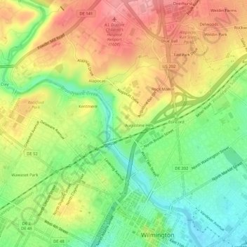
Name: Augustine topographic map, elevation, terrain.

Location: Augustine, New Castle County, Delaware, 12806, United States (39.74400 -75.57381 39.78400 -75.53381)

Average elevation: 177 ft

Minimum elevation: 0 ft

Maximum elevation: 361 ft

New Castle County trails, hiking, mountain biking, running and outdoor activities

Other topographic maps

Click on a map to view its topography, its elevation and its terrain.

Ardentown

United States > Delaware > New Castle County

Average elevation: 292 ft

Odessa

United States > Delaware > New Castle County

Average elevation: 33 ft

Arden

United States > Delaware > New Castle County

Average elevation: 259 ft

Newport

United States > Delaware > New Castle County

Average elevation: 43 ft

Elsmere

United States > Delaware > New Castle County

Average elevation: 98 ft

Townsend

United States > Delaware > New Castle County

Average elevation: 59 ft

Greenville

United States > Delaware > New Castle County

Average elevation: 276 ft

Claymont

United States > Delaware > New Castle County

Average elevation: 92 ft

Townsend

United States > Delaware > New Castle County

Average elevation: 59 ft

Gear up for your next adventure:

🔥Camping Stove - Portable stove for camping and backcountry cooking
🍳Camping Cook Set - Complete cookware for outdoor meals
🪶Multi‑Purpose Knife - Useful blade for camp and trail
🌡️Portable Weather Meter - Track weather conditions on the trail
🌧️Backpack Rain Cover - Keep gear dry in wet weather

As an Amazon Associate, this site earns from qualifying purchases at no extra cost to you.