
Make a donation
Gear up for your next adventure:
As an Amazon Associate, this site earns from qualifying purchases at no extra cost to you.
Κήποι topographic map
Click on the map to display elevation.
Make a donation
Gear up for your next adventure:
As an Amazon Associate, this site earns from qualifying purchases at no extra cost to you.
Κήποι
Kipoi (Greek: Κήποι, before 1928: Μπάγια – Bagia) is a village in the region of Zagori. It belongs to the municipal unit of Tymfi, Ioannina regional unit, Greece. The Greek name derives from the many gardens in the surrounding areas (Greek Κήποι=Gardens). The name "Bagia" is Slavic and means "warm (and low) place". The village has the lowest altitude of all Zagori village and is surrounded by rivers. It is built on a rocky hill, in the southern end of Vikos Gorge.
Make a donation
Gear up for your next adventure:
As an Amazon Associate, this site earns from qualifying purchases at no extra cost to you.
About this map
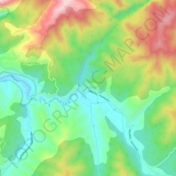
Name: Κήποι topographic map, elevation, terrain.
Average elevation: 2,858 ft
Minimum elevation: 2,359 ft
Maximum elevation: 3,658 ft
Make a donation
Gear up for your next adventure:
As an Amazon Associate, this site earns from qualifying purchases at no extra cost to you.
Other topographic maps
Click on a map to view its topography, its elevation and its terrain.
North Tzoumerka Municipality
Greece > Epirus and Western Macedonia > Ioannina Regional Unit
Average elevation: 3,248 ft