
Tolara topographic map
Interactive map
Click on the map to display elevation.
About this map
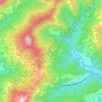
Name: Tolara topographic map, elevation, terrain.
Location: Tolara, Lumarzo, Genua, Ligurien, 16022, Italien (44.43062 9.09503 44.47062 9.13503)
Average elevation: 1,585 ft
Minimum elevation: 725 ft
Maximum elevation: 2,831 ft
Other topographic maps
Click on a map to view its topography, its elevation and its terrain.
Monte Cornua
Monte Cornua, Avegno, Genua, Ligurien, 16024, Italien
Average elevation: 1,385 ft
Forte Geremia
Italien > Ligurien > Genua > Mele
Forte Geremia, Polveriera, Mele, Genua, Ligurien, 16013, Italien
Average elevation: 1,896 ft