
Casella topographic map
Interactive map
Click on the map to display elevation.
About this map
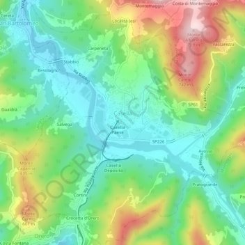
Name: Casella topographic map, elevation, terrain.
Location: Casella, Genua, Ligurien, 16015, Italien (44.51663 8.97674 44.55181 9.02608)
Average elevation: 1,650 ft
Minimum elevation: 1,240 ft
Maximum elevation: 2,448 ft
Other topographic maps
Click on a map to view its topography, its elevation and its terrain.
Monte Cornua
Monte Cornua, Avegno, Genua, Ligurien, 16024, Italien
Average elevation: 1,385 ft
Forte Geremia
Italien > Ligurien > Genua > Mele
Forte Geremia, Polveriera, Mele, Genua, Ligurien, 16013, Italien
Average elevation: 1,896 ft