
Cogoleto topographic map
Interactive map
Click on the map to display elevation.
About this map
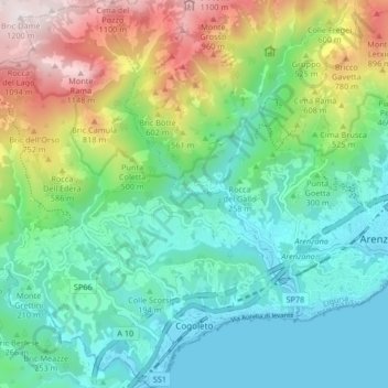
Name: Cogoleto topographic map, elevation, terrain.
Location: Cogoleto, Genua, Ligurien, 16016, Italien (44.37974 8.58503 44.43884 8.66483)
Average elevation: 1,132 ft
Minimum elevation: 0 ft
Maximum elevation: 3,901 ft
Other topographic maps
Click on a map to view its topography, its elevation and its terrain.
Monte Cornua
Monte Cornua, Avegno, Genua, Ligurien, 16024, Italien
Average elevation: 1,385 ft
Forte Geremia
Italien > Ligurien > Genua > Mele
Forte Geremia, Polveriera, Mele, Genua, Ligurien, 16013, Italien
Average elevation: 1,896 ft