Geolocate

Oban topographic map

Click on the map to display elevation.

About this map

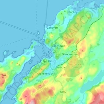
Name: Oban topographic map, elevation, terrain.

Location: Oban, Argyll and Bute, Scotland, PA34 5PZ, United Kingdom (56.37570 -5.51347 56.45570 -5.43347)

Average elevation: 154 ft

Minimum elevation: 0 ft

Maximum elevation: 778 ft

Other topographic maps

Click on a map to view its topography, its elevation and its terrain.

Torsa

United Kingdom > Scotland > Argyll and Bute > Cuan > Silver Moon

Average elevation: 39 ft

Texa

United Kingdom > Scotland > Argyll and Bute

Average elevation: 3 ft

Scarba

United Kingdom > Scotland > Argyll and Bute

Average elevation: 299 ft

Bute

United Kingdom > Scotland > Argyll and Bute > Townhead

Average elevation: 135 ft

Easdale

United Kingdom > Scotland > Argyll and Bute > Easdale

Average elevation: 26 ft

Tarbert

United Kingdom > Scotland > Argyll and Bute

Average elevation: 226 ft

Ardrishaig

United Kingdom > Scotland > Argyll and Bute

Average elevation: 217 ft

Coll

United Kingdom > Scotland > Argyll and Bute > Arinagour

Average elevation: 23 ft

Gear up for your next adventure:

🪶Multi‑Purpose Knife - Useful blade for camp and trail
🥩Freeze-Dried Meals - Nutritious and lightweight food for remote expeditions
🛠️Backpacking Tool Kit - Essential toolkit for outdoor repairs
🧭Hiking Compass - Precision compass for reliable navigation in the wilderness
🔥Fast-Boil Camping Stoves - Efficient cooking systems for quick trail meals

As an Amazon Associate, this site earns from qualifying purchases at no extra cost to you.